


|
||

|

|
|

|
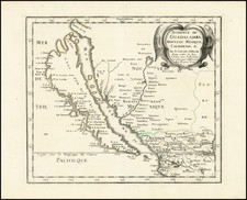
Nice example of Sanson's map of California and the Southwest, the first regional map of America to show California as an Island.
Prior to this map, all maps with California shown as an Island were either World maps, Western Hemisphere, North America, Pacific Ocean or some substantially larger geographical region.
The region illustrated was still largely unknown. The Rio Grande is shown flowing into the Sea of Cortez, an error which would not be corrected until Nicolosi's map. A number of New Mexican Villages are shown, including Taos and Santa Fe, along with several bands of Apache Indians. The Moqui, Zuni and Navajo names also appear.
This is the earliest map to show the so-called Second Sanson Model of insular California (two bays shown in Northernmost portion of the island). Nomenclature is a combination of Blaeu and Sanson and includes Cibola, Reg Coromedo and Lago de Oro, along with a reference to Pto. de Francisco Draco. California includes many early place names, such as San Diego, San Francisco, Canal de S. Barbara, Point Concepcion, Cape Mendocino, Point Reyes and a curiously located "Punta de Monte Rey," well north of its correct location.
The peninsula above California is a curious and unexplained addition. Quivira is also shown, but located in eastern New Mexico, far from its normal location on the Northwest Coast.
This example is the 1683 Ribbius edition, with the line break in the title between "Abbe" and "ville"
A seminal map, which influenced California Cartography for the next 50 years. A cornerstone map for California collectors.
Nicholas Sanson (1600-1667) is considered the father of French cartography in its golden age from the mid-seventeenth century to the mid-eighteenth. Over the course of his career he produced over 300 maps; they are known for their clean style and extensive research. Sanson was largely responsible for beginning the shift of cartographic production and excellence from Amsterdam to Paris in the later-seventeenth century.
Sanson was born in Abbeville in Picardy. He made his first map at age twenty, a wall map of ancient Gaul. Upon moving to Paris, he gained the attention of Cardinal Richelieu, who made an introduction of Sanson to King Louis XIII. This led to Sanson's tutoring of the king and the granting of the title ingenieur-geographe du roi.
His success can be chalked up to his geographic and research skills, but also to his partnership with Pierre Mariette. Early in his career, Sanson worked primarily with the publisher Melchior Tavernier. Mariette purchased Tavernier’s business in 1644. Sanson worked with Mariette until 1657, when the latter died. Mariette’s son, also Pierre, helped to publish the Cartes générales de toutes les parties du monde (1658), Sanson' atlas and the first French world atlas.
![[ Texas-Mexico Border Treaty ] Que á efecto de facilitar el cumplimienio [i.e. cumplimiento] del art. 3. del Tratado de limites entre estos Estados y los Unidos del Norte América ... Habiéndose concluido y firmado en la Ciudad de México á los 12 dias del mes de Enero de 1828, un tratado entre los Estados-Unidos Mexicanos y los Estados-Unidos de América [A Treaty having been concluded and signed in the City of Mexico on the 12 day of January 1828 between the United States of America and the Mexican United States for the purpose of establishing the true dividing line and boundary between the two nations]](https://storage.googleapis.com/raremaps/img/small/100806.jpg)
![[First Obtainable Map to Name California] Tartariae Sive Magni Chami Regni typus](https://storage.googleapis.com/raremaps/img/small/82510.jpg)