


|
||

|

|
|

|
Stock# 65480
Description
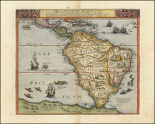
Fine large map of South America, illustrating the continent on the eve of its decades of revolution.
The map illustrates the limited knowledge of Europeans in the interior parts of the continent.
Among the more interesting features are the designations "Amazones Espagnole" and Amazones Portugaise," showing the regions of the Amazon controlled by the two major colonial powers, as divided in the 16th century by the Pope.
The map is finished with an elaborate allegorical cartouche, showing America as woman feeding her children, while an industrious European secures goods for the voyage across the Atlantic back to Europe.
![America [Manuscript Map Showing the Sea of the West!]](https://storage.googleapis.com/raremaps/img/small/41297dm.jpg)
![Tabula Terre Nove [The Admiral's Map]](https://storage.googleapis.com/raremaps/img/small/81714.jpg)