|
||

|

|
|

|
Stock# 65143
Description
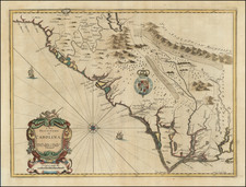
Fine example of this scarce map of the coast of South Carolina from the English Pilot, Fourth Book, including fascinating 18th Century provenance.
Nice example of the third state of this fine chart of South Carolina, updated by Mount & Page just after the conclusion of the French & Indian War. The map provides soundings and shows the settlements along the coast.
It was originally drawn from Mathews manuscript map of 1685, with substantial additions. Extensive place names, rhumb lines, soundings, compass Rose, etc.
![A New Map of Virginia [Chesapeake]](https://storage.googleapis.com/raremaps/img/small/43053.jpg)
![(Colonial Charleston, South Carolina) This Indenture... [Land documented signed at Charles Town, South Carolina, 14th of August, 1772 by William and Ann Holmes]](https://storage.googleapis.com/raremaps/img/small/92691.jpg)