


|
||

|

|
|

|
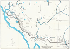
Unrecorded Map Illustrating the Lands of A French Real Estate Investment Venture Just West of Fort Worth
Rare cadastral map illustrating the lands west of Fort Worth,Texas owned by the Societe Fonciere et Agricole des Etats-Unis.
The region illustrated is centered on Brazos Texas and comprises a significant portion of Parker and Palo Pinto Counties, extending to about 15 miles west of Fort Worth Texas. While we find no survivng records describing the map, it was almost certainly prepared in conjunction with efforts to promote the sale of land in the area to French buyers interested in farming the region.
The map is also a remarkable record of contemporary land ownership in th region, with dozens of land ownership (or farmers) names given. The map legend identifies:
- Towns and railroad stations
- Lands owned by the Societe (in pink, with cadastral numbers -- each square being 256 hectares)
- Cultivated land and names of owners and farmers (in green)
- Miscellanous lands (uncolored)
- Railroad lines in operation (solid black lines)
- Railroad lines under construction (dashed black lines)
The map illustrates the location of the lands which the Societe Fonciere et Agricole des Etats-Unis purchased from the Franco-Texan Land Company in 1879, at a point when the Franco-Texana Land Company was reorganizing. While the region in question would go on to become a productive region Cattle, it seems that by 1883, the Societe Fonciere et Agricole des Etats-Unis had failed and the land it acquired had been foreclosed upon by Sam H. Milliken.
The map title translates as "Land and Agricultural Society of the United States". Engraved and printed by Erhard in Paris, this would appear to be the only surviving example of this rarity.
The Franco-Texan Land Company
The Franco-Texan Land Company (charted in Texas on August 4, 1876), owned about 600,000 acres of land in Parker, Palo Pinto, Stephens, Callahan, Shackelford, Mitchell, Taylor, Nolan, Jones, and Fisher counties. The company had its origin in an 1856 land grant made by the Texas legislature to the Memphis, El Paso and Pacific Railroad, which authorized construction of a railroad from a point on the eastern boundary of the state between Sulphur Fork and the Red River to a point on the Rio Grande opposite or near the city of El Paso. The state donated sixteen sections of 640 acres each for every mile of road constructed and placed in running order, on the completion of a minimum of ten miles, and eight sections per mile for the grading of a minimum of twenty-five miles of roadbed.
By 1861 the Memphis, El Paso and Pacific directors had surveyed the center line of the road as far as the Brazos River and graded fifty-five miles on which they were ready to lay the track. The Civil War suddenly halted all operations. In 1866 the legislature extended the company's contract for ten years. To raise new capital, the directors brought John Charles Frémont into the company. Frémont, envisioning a transcontinental road on the thirty-second parallel, beginning at San Diego and connecting with the East at Memphis, took control and promptly executed three mortgages secured by the road itself and the land grants yet to be received from the state of Texas. Frémont sold his securities in France and collected some $5 million after he had succeeded in getting his "puffed-up" bonds quoted on the Paris Bourse.
Because scandal surrounding the bonds and the relatively small sum actually spent on the railroad, Congress refused to grant Frémont a transcontinental charter. As a result, the line was sold to the rival Texas and Pacific Company and the French bondholders became the owners of the Texas land that secured their bonds, subject, however, to rules and regulations imposed by John A. C. Gray, the agent who put the Memphis, El Paso and Pacific into receivership and sold it to the Texas and Pacific.
The French bondholders received thirteen acres of land for each $100 bond, which became the capital stock of the Franco-Texan Land Company. The incorporators were H. E. Alexander and S. Pinkney Tuck of New York, and Claiborne S. West and Harry C. Withers of Austin, Texas. Tuck, the company's secretary, traveled to Weatherford, Texas, and began the sale of land in 1878. Henry P. du Bellet, vice secretary residing in Paris, ousted the management group and Sam H. Milliken of Weatherford was elected president. Du Bellet then came to Texas and had a hand in the company's affairs until he too was ousted. Successive presidents were V. G. Frost of Palo Pinto, A. Chaptive of Paris, France, R. W. Duke and A. J. Hood of Weatherford, Texas, and George P. Levy of Paris, France. With the gradual increase in the value of Texas land, the Franco-Texan Land Company developed into something of a bonanza for the French and American directors, who bought stock certificates for a few cents on the dollar and conspired to riddle the company's coffers. The losers were the French peasants who had invested their life savings in the Memphis, El Paso and Pacific bonds. In 1896, after years of local rivalry and dissension, the charter of the Franco-Texan Land Company expired by limitation. On request, the legislature allowed the company three additional years to liquidate its assets and conclude its business.
As noted in the Synopsis of Virginia H. Taylor's The Franco-Texan Land Company (2011),
The Franco-Texan Land Company was formed . . . by the French bondholders of the Memphis, El Paso, and Pacific Railroad in an attempt to salvage their investments through sale of lands in the railroad's Texas land grant. Most of the land company's wealth, however, went into the pockets of unscrupulous local managers and directors, and another railroad eventually built a road across Texas along the Memphis, El Paso, and Pacific right of way. Despite their unsavory histories, the land company and its railroad parent played an important part in the development of Northwest Texas. . .
Rarity
The map is extremely rare. We locate no surviving examples.
The map is listed in the Bibliographie de la France, at page 396 in 1881, suggesting the map was published in 1879 or 1880. This is apparently "Carte No. 2." A "Carte No. 1" with the title : Carte des États-Unis donnant la situation des terres de la Société dans l'Etat du Texas, is also listed. We were unable to locate an example of either map in any modern library or reference work.

![(Nacogdoches County, Texas) [Preemption Land Grant, signed by Governor Elisha M. Pease,1857 - Texas Land Grant on Dill's Creek] Preemption. In the Name of the State of Texas](https://storage.googleapis.com/raremaps/img/small/88915.jpg)
