|
||

|

|
|

|
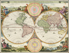
Second Earliest World Map on an Oval Objection - One of the Earliest Obtainable Map To Show America -- Earliest Obtainable World Map to Appear in an Isolario
Important early map of the World, being the first world map to appear in an "Isolario" and the second earliest map published on an oval projection.
Bordone's world map, one of few pre-Munster world maps that are reasonably obtainable for collectors, was responsible for popularizing the oval projection. It is preceded in use of the projection only by the separately-published map of Rosselli, which is known in only a few examples. Bordone's was the first widely disseminated map to employ this projection and was later followed by a number of major mapmakers, including, Grynaeus (1532), Munster (1540), Gastaldi (1546), a number of Lafreri maps, and Ortelius (1570/1587).
Benedetto Bordone was originally granted a privilege to print his world map as early in 1508, however no earlier work is known prior to 1528. Bordone's map is similar to the Rosselli map of ca. 1508, but with an evolved view of America. Unlike Rosselli, Bordone omits all Antarctic lands and separates the continents of Asia and America. The lines crossing the map represent six wind directions, which are named in scripted text outside the map’s edge. Because the Rosselli is so rare, this map by Bordone is the earliest obtainable map to use an oval projection.
Bordone depicts a modern Africa, but a Ptolemaic India and Ceylon. Southeast Asia is modelled after the typical thinking of the time, a large subcontinent offsetting the Austronesian islands to the south. Japan is shown hypothetically after Polos' textual account. The island of Madagascar is duplicated, and the Indus and Ganges Rivers are reversed.
Bordone's map appeared in his Libro di Benedetto Bordone ... de tutte l'Isole del mondo . . . first published in Venice in1528. This Isolario would go on to become one of the most commercially successful and influential geographical works of the first part of the 16th Century. Books of islands or Isolario were very popular in fifteenth and sixteenth century Italy. Several early manuscript volumes are known, while the earliest printed Isolario was published in about 1485 by Sonetti and included 49 maps of the Greek islands. Bordone’s island book, which first appeared in 1528 and was the second printed Isolario, greatly expanded the subject matter as it attempted to chart the islands of the entire world.
An important early map of the World for collectors.
Benedetto Bordone (1460-1531) was a polymath who was born in Padua and worked in Venice. He was an illuminator, engraver, miniaturist, editor, and geographer. It is possible he made the first globe in Italy. His most famous work is the Isolario, or Book of Islands, which included many of the earliest printed maps of islands in the New World.
![Eastern Hemisphere [with] Western Hemisphere](https://storage.googleapis.com/raremaps/img/small/98321.jpg)