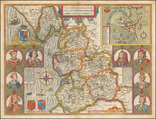
The First Printed Map of Kent, Sussex, Surrey and Middlesex, drawn from Christopher Saxton's 16th Century Survey of England.
Fine example of Christopher Saxton's map of Kent, Sussex, Surrey and Middlesex, dated 1575, the 17th year of the Reign of Queen Elizabeth I. The present example is state 2 of the map, which is the state of the map that appeared in Saxton's atlas and includes the following changes from the proof state of 1575:
- Pestis Patriae Pigricies added above the Seckford Coat of Arms.
- Christopherus Saxton description has been added at bottom right.
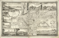
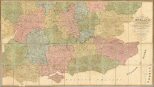
This is one of the earliest and most important English maps, covering the Southeastern part of England and dissected by the Thames River, with London prominently located near the top center of the map. Embellished with sailing ships, sea monsters and an elaborate strapwork cartouche and scale of miles, it is among the most important 16th Century English maps.
Christopher Saxton (1540-1610) was an English cartographer who produced the first county maps of England and Wales.
Generally regarded as the Father of English Cartography, Saxton was born near Dewsbury in Yorkshire. His first work was as an assistant to the vicar of Dewsbury, John Rudd, who was also a skilled mapmaker. Rudd's interest in surveying dates to as early as 1534, and by 1560 it was known that he planned to carry out a general survey of England. Rudd almost certainly introduced Saxton to the Lord Treasurer, Lord Burghley and Thomas Seckford, a lawyer and influential court official as Master of Requests.
Working under the patronage of Seckford, Saxton began his own surveys in 1570 and the first maps were completed in 1574. He was granted a ten-year license to make and market maps in 1577. There are no records of Saxton's methods of survey but he would also have relied on the Lily and Mercator maps, estate maps, local surveys and on the results of John Rudd's surveys.
Saxton created the first map plates for his printed survey by1574 and in 1578 the survey was complete. Individual county sheets were issued before the completed survey was issued as an atlas in 1579.
The maps were produced in the Atlas of the Counties of England and Wales published in 1579, the first atlas of any country. It contained 35 maps, each bearing the arms of Elizabeth I and Thomas Seckford, Saxton's patron.
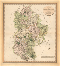
All the maps are dated except for Northumberland. Five counties, Cornwall, Essex, Hertfordshire, The Suffolk and Norfolk maps show the division into hundreds. The atlas was a commercial success, prompting other cartographers including John Speed, John Norton, and Michael Drayton to attempt similar enterprises, adding to and adapting Saxton's work.
The maps drawn by Saxton were engraved by Augustine Ryther, Remigius Hogenberg, William Hole, William Kip, Leonard Terwoort of Antwerp, Nicholas Reynold of London, Cornelius Hogius, and Francis Scatter. The engravers were of Dutch or Flemish origin.
Christopher Saxton (c. 1540–c. 1610) was an influential English cartographer, best known for producing the first comprehensive atlas of England and Wales in 1579. His detailed and methodical maps laid the foundation for English cartography and shaped how maps were created and used in the British Isles.
Early Life and Training
Saxton was born around 1540 in the parish of Dunningley, West Yorkshire. While little is known about his early education, he likely had training as a surveyor and draftsman. His introduction to cartography might have been through John Rudd, vicar of Dewsbury and a skilled mapmaker himself. Rudd’s mentorship likely influenced Saxton’s focus on detail and accuracy in his work.
Connections in Government and Cartography
Saxton's career took a decisive turn through his connections with Thomas Seckford, a powerful courtier and member of Queen Elizabeth I's government. Seckford, who held the title of Master of Requests, was instrumental in supporting Saxton’s rise. Recognizing the need for accurate maps for governmental and military purposes, Seckford secured Saxton’s commission to create a detailed survey of England and Wales.
Saxton’s project had the full backing of the Crown. He received letters of authorization from Elizabeth I, which provided him protection and access to local officials during his surveys. This royal endorsement ensured Saxton's cooperation with local authorities as he traveled to gather data. The support from Seckford and the government reflects how critical accurate cartography was for administrative, military, and taxation purposes during this period.
Saxton’s Atlas of England and Wales
From 1573 to 1579, Saxton conducted detailed surveys across England and Wales, often working with surveyors, draftsmen, and engravers. His atlas, published in 1579 as Atlas of the Counties of England and Wales, was a groundbreaking achievement. It contained 35 maps, each representing one county, and presented an unprecedented level of geographical accuracy and detail. The maps were engraved by leading engravers of the day, including Augustine Ryther and Remigius Hogenberg.
This atlas was not only a monumental achievement in cartography but also a significant political and military tool for Elizabethan England, aiding administrative control and supporting defense efforts, particularly in anticipation of foreign threats like Spain.
Innovations and Influence
Saxton’s maps set a new standard in English cartography. He was among the first English cartographers to include latitude and longitude markings and detailed topographical information, such as rivers, mountains, and towns. His work was visually striking, incorporating ornate decorations, coats of arms, and symbols representing important buildings and cities. These features made his maps both functional and aesthetically appealing.
His detailed surveys laid the groundwork for future mapmakers and had a lasting influence on English cartography. Later figures, such as John Speed, heavily relied on Saxton’s work. Speed’s The Theatre of the Empire of Great Britaine (1611–12) incorporated many of Saxton’s innovations but added further historical and descriptive elements.
Later Life and Legacy
Saxton continued to work as a surveyor after his atlas was published, though much of his later life remains obscure. His contributions to cartography, however, remain indisputable. His maps were used, reprinted, and refined by future generations of mapmakers. The engravings from his atlas continued to be used well into the 17th century, with new editions appearing long after his death.
Christopher Saxton's legacy as a pioneering figure in English cartography is profound. His connection to powerful patrons like Thomas Seckford and the royal endorsement for his work illustrate the intersection of cartography with government and political power in Elizabethan England. His maps were not only scientific achievements but also important tools of statecraft, symbolizing the Crown’s control over its territories.
Saxton likely died around 1610, but his Atlas of England and Wales remains a foundational work in the history of cartography.