


|
||

|

|
|

|
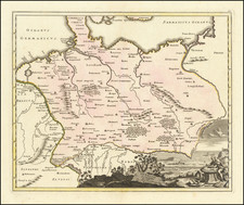
Nice example of Blaeu's rare map of Poland, Lithuania, etc., which first appeared in the 1662 edition of Blaeu's Atlas Maior.
This is Blaeu's second map based upon Radizwill's early map, originally engraved by Hessel Gerritsz. The Radziwill map is one of the most important works of European cartography from the end of the 16th and the beginning of the 17th century and is an important contribution to the progress in the mapping of the whole continent. The map had its beginning in 1586 when Prince Michael Radziwill commissioned M.Strubicz to survey the entire Lithuanian state which then included Poland. Strubicz's map was so accurate and detailed that it provided the basis for all subsequent maps of the area during the 17th and 18th centuries. In addition to the usual topographical details, there is considerable historical information also provided.
The present edition is oriented with west at the top.
Because the map appeared only in the very late editions of Blaeu's Atlas Maior, it is relatively scarce on the market. A similar map was done by Jansson, based upon the Radizwill map, but is easily distinguished from the Blaeu map as it also includes an inset of the Dniepr River.
Joan, or Johannes, Blaeu (1596-1673) was the son of Willem Janszoon Blaeu. He inherited his father’s meticulous and striking mapmaking style and continued the Blaeu workshop until it burned in 1672. Initially, Joan trained as a lawyer, but he decided to join his father’s business rather than practice.
After his father’s death in 1638, Joan and his brother, Cornelis, took over their father’s shop and Joan took on his work as hydrographer to the Dutch East India Company. Joan brought out many important works, including Nova et Accuratissima Terrarum Orbis Tabula, a world map to commemorate the Peace of Westphalia which brought news of Abel Tasman’s voyages in the Pacific to the attention of Europe. This map was used as a template for the world map set in the floor of the Amsterdam Town Hall, the Groote Burger-Zaal, in 1655.
Joan also modified and greatly expanded his father’s Atlas novus, first published in 1635. All the while, Joan was honing his own atlas. He published the Atlas maior between 1662 and 1672. It is one of the most sought-after atlases by collectors and institutions today due to the attention to the detail, quality, and beauty of the maps. He is also known for his town plans and wall maps of the continents. Joan’s productivity slammed to a halt in 1672, when a fire completely destroyed his workshop and stock. Joan died a year later and is buried in the Westerkerk in Amsterdam.
![[ Eastern Poland ] Der Koniglichen Republik Polen Woiwodschaften Podlachien mit dem obern Theileder Woiwodschafter Lublin, oder Klein Polens…](https://storage.googleapis.com/raremaps/img/small/102985.jpg)
![Europae Tabula VIII [Russia, Ukraine, Baltic, Scandinavia]](https://storage.googleapis.com/raremaps/img/small/86526.jpg)
![[Crimea / Ukraine Battle Map ] Charte der Kriegs Operationen am Donn und Dniepr Ihro Russisch Key Serl: Maiest: Glorieusen Armeen A: 1736 gestorchen bey der keyserl: Acad: der Wissensch: in St. Petersb.](https://storage.googleapis.com/raremaps/img/small/101811.jpg)