|
||

|

|
|

|
Stock# 64792
Description
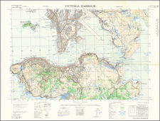
Detailed War Office and Air Ministry Chart of Hong Kong.
Detailed British military mapping of Hong Kong, this is the second (southern) of two sheets.
The sheet is labeled as a first edition and has as its source RAF Air Survey photography from November 1954, supplemented with ground survey revisions through August 1957. And, probably as the base map, the GSGS 3691 1:80,000 (1946) mapping of Hong Kong and the GSGS 3861 1:20,000 (1951-52) mapping.
As was the tradition at the time, the map's key differentiates between different kinds of roads, telegraph and telephone lines, villages, hamlets, etc., different land cover, and some bathymetric information.
![[Hong Kong / Macao / Canton] Asie No. 98. Partie de La Chine](https://storage.googleapis.com/raremaps/img/small/64115.jpg)