


|
||

|

|
|

|
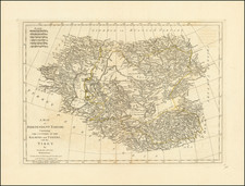
Detailed map of the Persian Empire, published by Homann.
The maps extends from the Black Sea, Khasikstan and Turkistan in the North to the Red Sea, Persian Gulf, Euphrates and the Mediterranean in the South, showing almost all of Cyprus. Decorative map, showing cities, mountains, rivers, lakes, roads, etc.
Large decorative carouche and smaller cartouche.
Johann Baptist Homann (1663-1724) was a mapmaker who founded the famous Homann Heirs publishing company. He lived his entire life in Bavaria, particularly in Nuremberg. Initially, Johann trained to become a priest before converting to Protestantism and working as a notary.
In 1702, Johann founded a publishing house that specialized in engravings. The firm flourished, becoming the leading map publisher in Germany and an important entity in the European map market. In 1715, Johann was named Imperial Geographer to the Holy Roman Empire by Charles VI and made a member of the Prussian Academy of Sciences. Most importantly for his business, his reputation and contacts gained him imperial printing privileges which protected his publications and recommended him to customers. Johann is best known for this Grosser Atlas ueber die ganze Welt, or the Grand Atlas of the World, published in 1716.
After Johann died in 1724, the business passed to his son, Christoph (1703-1730). Upon Christoph’s early death, the company passed to subsequent heirs, with the name of the company changing to Homann Erben, or Homann Heirs. The firm continued in business until 1848.
![[ Hindus - Fire worshipers from outskirts of Baku ] Indiens (Habitants de Bakou, adonnes au culte du feu) Индусы Огнепоклонники изъ окрестностей баку)](https://storage.googleapis.com/raremaps/img/small/86593.jpg)
![Carte de la Turquie, de l'Arabie et de la Perse, dressée sur les mémoires les plus récents rectifiée par les observations de Messieurs de l'Académie Royale des Sciences par G. de L'Isle, géographe. [Map of Turkey, Arabia, and Persia, drawn up based on the most recent memoirs and corrected by the observations of the gentlemen of the Royal Academy of Sciences by G. de L'Isle, geographer.]](https://storage.googleapis.com/raremaps/img/small/94075.jpg)
![The Turkish Empire in Asia [shows Cyprus]](https://storage.googleapis.com/raremaps/img/small/37050.jpg)