


|
||

|

|
|

|
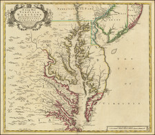
First State of Sanson's Landmark Map of the Southern Parts of North America
Fine example of Nicolas Sanson's landmark regional map of North America, being the first large scale map to depict California and the Southwest and Sanson's first large format regional map of any portion of North America.
Sanson's map of the southern part of North America has the distinction of being the first large format regional map of North America prepared by this highly influential French mapmaker, whose revolutionary approach to the presentation of geographical knowledge on a printed map was responsible not only for the advancing French cartographic knowledge to the forefront of Europe's mapping of the New World, but perhaps even more importantly was responsible for profoundly altered the style and discipline associated with the graphic depiction of cartographic imagery, the essence of the map maker's art for the next 100 years. Before Sanson, the era begun by the Italian perspective artists of the 15th and 16th centuries and refined in the Low Countries by the skills of the fine master engravers of the Golden Age of Dutch Cartography objectivized maps not only for their content, but also as works of art. In Sanson's work, the embellishment of geographical imagery begins to give way to the science of geographical and spatial depiction. While it would be another 100 years before the mapmaker's art would truly be eclipsed by science, Sanson's work is without question and important point of inflection in this history, adding importance to this his first large format regional map of North America.
Sanson's map is the earliest to concentrate on Spanish territories from Florida to California and provided a prototype for other mapmakers over the next 50 years. Engraved by Jean Somer, it improves upon Sanson's Amerique Septentrionale in many ways. Amongst them is the first application of ERIE LAC to a recognizable lake. The depiction of California as an island was one of two most influential models (the other being the Briggs model), and was used as a model by many later cartographers.
First published separately, the map appeared in Sanson's atlases and later in composite atlases for the next 70 years. The Pierre Mariette in the title is the son of Nicolas Sanson's business partner of the same name, who provided the original investment for Sanson's business, but died in 1657. The Northwest Coastline is substantially revised from Sanson's map of North America. The Rio Grande, still mistakenly flowing southwest, includes many new Indian Names not present in the map of North America. The curious peninsula at the top of the Northwest Coast of the mainland (Agubela De Cato) is of unknown origin.
States of the map
There are four states of the map. The states can be identified as follows:
- State 1: Date on the map (1656) and the imprint "Chez Pierre Marriett, Rue S. Iaque...1656."
- State 2: Imprint reads: "Chez l'Autheu...1656."
- State 3: Adds an "r" to the word "Autheu," but retains the 1656 date.
- State 4: Dated 1679.
Nicholas Sanson (1600-1667) is considered the father of French cartography in its golden age from the mid-seventeenth century to the mid-eighteenth. Over the course of his career he produced over 300 maps; they are known for their clean style and extensive research. Sanson was largely responsible for beginning the shift of cartographic production and excellence from Amsterdam to Paris in the later-seventeenth century.
Sanson was born in Abbeville in Picardy. He made his first map at age twenty, a wall map of ancient Gaul. Upon moving to Paris, he gained the attention of Cardinal Richelieu, who made an introduction of Sanson to King Louis XIII. This led to Sanson's tutoring of the king and the granting of the title ingenieur-geographe du roi.
His success can be chalked up to his geographic and research skills, but also to his partnership with Pierre Mariette. Early in his career, Sanson worked primarily with the publisher Melchior Tavernier. Mariette purchased Tavernier’s business in 1644. Sanson worked with Mariette until 1657, when the latter died. Mariette’s son, also Pierre, helped to publish the Cartes générales de toutes les parties du monde (1658), Sanson' atlas and the first French world atlas.
![Nouvelle Carte Du Mexique, Du Texas Et D'Une Partie Des Etats Limitrophes . . . 1840 [Proposed Railroads In Texas -- First Appearance of Arizona on a Printed Map]](https://storage.googleapis.com/raremaps/img/small/103480.jpg)
![[ First Modern Map of Texas Coast ] The Western Coast of Louisiana and The Coast of New Leon](https://storage.googleapis.com/raremaps/img/small/38972.jpg)
