|
||

|

|
|

|
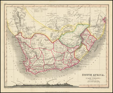
De L’Isle’s Fine Map of Southern Africa
Striking example of De L'Isle's impressive map of South Africa and Madagascar, showing De L’Isle’s characteristic precision and attention to detail.
Stretching from Congo in the north to what is now South Africa in the south, the map also includes Madagascar. The map is full of information about geographic features, especially lakes and rivers, natural resources, and indigenous peoples. Political boundaries are sketched, as are settled areas.
The map is based on De L’Isle’s revised map of the continent of Africa, published in 1700. He shortened the width of the Mediterranean, and northern Africa, by twenty degrees as compared to Ptolemaic versions. In addition to his map of the entire continent, De L’Isle followed with three regional African maps: Northeast Africa, West Africa, and South Africa, which is this map, published in 1708.
Relevant to this map, De L’Isle reviewed existing evidence for features in the interior of Africa. He removed the lake system and Mountains of the Moon that stretched from southern Africa north; these were the traditional source of the Nile as described by Ptolemy. He retained a large lake in the region, however, here without name but “according to the report of the Africans.”
Unlike on the southern part of the continent map, this map contains a large mountain range stretching from southwest to northeast. The note running along the range says, “Mountains of Lupata, called the ‘Backbone of the World’ by the Cafres [local people]”. This feature, and many of De L’Isle’s other details of African cartography, were repeated on later maps throughout the eighteenth century.
Guillaume De L'Isle (1675-1726) is probably the greatest figure in French cartography. Having learned geography from his father Claude, by the age of eight or nine he could draw maps to demonstrate ancient history. He studied mathematics and astronomy under Cassini, from whom he received a superb grounding in scientific cartography—the hallmark of his work. His first atlas was published in ca. 1700. In 1702 he was elected a member of the Academie Royale des Sciences and in 1718 he became Premier Geographe du Roi.
De L'Isle's work was important as marking a transition from the maps of the Dutch school, which were highly decorative and artistically-orientated, to a more scientific approach. He reduced the importance given to the decorative elements in maps, and emphasized the scientific base on which they were constructed. His maps of the newly explored parts of the world reflect the most up-to-date information available and did not contain fanciful detail in the absence of solid information. It can be fairly said that he was truly the father of the modern school of cartography at the commercial level.
De L’Isle also played a prominent part in the recalculation of latitude and longitude, based on the most recent celestial observations. His major contribution was in collating and incorporating this latitudinal and longitudinal information in his maps, setting a new standard of accuracy, quickly followed by many of his contemporaries. Guillaume De L’Isle’s work was widely copied by other mapmakers of the period, including Chatelain, Covens & Mortier, and Albrizzi.
![(Horn of Africa) Abessinien Somaliländern [cover title:] Neue Karte von Abessinien und Somaliländern](https://storage.googleapis.com/raremaps/img/small/97482.jpg)
![Карта Восточной Части Африки [Map of the Eastern Part of Africa]](https://storage.googleapis.com/raremaps/img/small/66634.jpg)