|
||

|

|
|

|
An Exceptional English Rarity
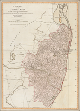
Very important, and rare, English chart of the Ganges River delta and northern coast of the Bay of Bengal, drawn from materials supplied by the East India Company to the London chartmaker and publisher, John Thornton.
The chart poses all manner of condundrums, not least of which is that there is no evidence in the Company’s files of Thornton ever having been Official Hydrographer to the East India Company, and yet, give the quasi-official nature of this publication, he must surely have had some grounds to lay claim to that title.
The map is found in the rare First Edition of John Thornton’s English Pilot The Third Book, 1703, a pilot guide with charts describing the sea-route round Africa to the East Indies and Far East, the first volume of its kind published anywhere in Europe. This First Edition is recorded in four institutional locations. Yet, this chart is stylistically uncharacteristic of the other charts in the book, suggesting a separate origin, perhaps twenty years earlier, so first published about 1680. Certainly this example did not originate in a copy of the Third Book as the charts from the ‘English Pilot’
were never coloured, while maps and charts from contemporary composite atlases generally were.
Rodney Shirley records two copies of the map in the British Library, one in the Third Book, and one in a composite Thornton sea-atlas, with the title-page Atlas Maritimus ..., which he dates after
1702.
It the earliest detailed delineation of this area to be offered for public consumption; a proof of a comparable map, attributed to Moses Pitt (active as a map-publisher to about 1684), is recorded in two copies, both in collections closely associated with the East India Company, a further reason for moving the original publication date back to the early 1680s.
Rarity
The map is extremely rare. We note only the example in the British National Maritime Museum, British Library and the Bibliotheque National de France.
We note an example of the later Samuel Thornton state in the New York Public Library, Library of Congress and Biblioteca National de Chile.
Description by Ashley Baynton-Williams
John Thornton was a respected and prominent chartmaker in London in the latter part of the seventeenth century. He was one of the final members of the Thames School of chartmakers and served as the hydrographer to the Hudson's Bay Company and the East India Company. He produced a large variety of printed charts, maps, and atlases in his career, but he was also a renowned manuscript chart maker. Born in London in 1641, he was apprenticed in the Drapers Company to a chartmaker, John Burston. After being made free of the company (1665), he was part of the combine that took over John Seller’ English Pilot in 1677. Thornton was trusted by the naval and navigational establishment of the day; one of his clients was Samuel Pepys, naval administrator and diarist. Thornton died in 1708, leaving his stock to his son, Samuel, who carried on the business.
Samuel, born in ca. 1665, also had apprenticed in the Drapers Company and was made free a year after his father’s death. He continued the business until 1715, when he died. His stock then passed to Richard Mount and Thomas Page.
![[India] Tab. X. Asiae Complectens India intra Gangem](https://storage.googleapis.com/raremaps/img/small/78289.jpg)
![Rangoon [Yangon, Birmah]](https://storage.googleapis.com/raremaps/img/small/90251.jpg)