|
||

|

|
|

|
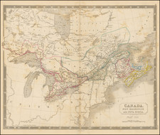
1821 edition of John Purdy's rare and important map of Cabotia (Canada), published by James Whittle and Richard Holmes Laurie.
Purdy's map is one of the most remarkable maps of the region published at the beginning of the 19th Century. The map is exceptionally detailed, especially in its treatment of the lands adjacent to the St. Lawrence River and respecting the various boundaries between the U.S. and Canada, and in its treatment of the roads and settlements throught the map. The notes include:
- A lengthy note about why Purdy chose the name Cabotia (see below)
- A lengthy note promoting Purdy's important Memoir, descriptive and explanatory, to accompany his Chart of the Atlantic Ocean.
- Details on important treaties
- Multiple notes on the vegitation topography and habitability of various regions
- A lengthy description of the Niagara Escarpment in the Frontier of Niagara Inset
- A note on the population of Newfoundland in 1789 and the various fishing treaties up to 1814 in the Newfoundland Inset
- A note on the navigability of the St. John's River and the poor choice of the Name St. John for Prince Edward Island
- A note in the Halifax Harbour inset regarding the founding of the the town of Halifax in 1749 (inset)
- A note on the rise in tide and navigability of the falls area near St. Johns, New Brunswick (inset)
The map is a richly annotated and meticulously researched compilation of important contemporary data. Purdy includes a marvelous note in Ohio in the first state of his map, where he states "Communication for the future improvement of this or any other part of the Map will be very accepable and punctually attended to." Clearly, his admonition was not ignored, as by the second state, this note has been removed and in its place there is extensive new information in Ohio, which appears to the region which has seen the most significant updating between the first and second states of the map. The first state of the map can be seen here: www.davidrumsey.com/luna/servlet/detail/RUMSEY~8~1~2622~220059:A-Map-Of-Cabotia--Comprehending-The
The detail of the towns and roads on both sides of the border is among the finest of the period, vastly surpassing the work done by Melish, Tanner, Bradley and others in the region. Important annotations include:
- Lord Edward Fitzgerald's Route towards Quebec in 1789 across northern Maine
- The Nine Ranges of Townships in Maine
- Bingham's Purchase (1 Milliona Acres) in Maine
- Bowdain College Tonwships in Maine
- The navigable limits of the Penobscot River
- The Battle of Fallen Timbers near Miami Ohio, August 20, 1794
Michigan Territory consists primarily of Indian Districts and two large notes, "Elevated Plain" and "Lands Not Yet Surveyed," although there is considerable detail regarding settlments on the St. Clair River, including Detroit, Brownstown and Grosse I.
The name Cabotia was apparently intended to honor the discoverer John Cabot, the discoverer of North America. It is one of several fascinating early names considered for various regions of North America, including Fredonia (as a name for the United States, which was also memorialized cartographical by Richard Holmes Laurie, with the name Cabotia also appearing in Laurie's map of Fredonia) and Sebastia, a name briefly considered by the Continental Congress prior to the 13 British Colonies becoming the United States (see, Report of the Librarian, American Antiquarian Society, p. 270, October 1954).
The names Cabotia (and Sebastiana) were not new inventions. As set forth in Purchas's Pilgrim at p. 792: America is a more common than fitting name, seeing Americus Vespucius the Florentine, from whom this nane is derived, was not the first finder nor author of that discovery . . . so it might more rightly be termed Cabotia or Sebastiana, of Sebastian Cabot, a Venetian, which discovered more of the continent than . . . both (Vespucci and Columbus), about the same time, first emplyed by king Henry the seventh of England.. . .
As noted on the map:
The portion of Trans-Atlantic Britain, herein denominated Cabotia, is a part only of that vast extent of North America which was discovered under the reign of Henry VII King of England, and which ought, in the interval of ags, to have been distinguished.
It was under a commission from Henry VII, that Giovanni Caboto, or John Cabot, with his Son Sebastian, jointly and separately, explored the Coasts of Baffins Strait to Florida; the whole of which was discovered, by these Navigators, not later than in 1497, and a year before Coon had seen the continent to the Southward.
The elder Cabot was a native of Venice, who settled at Bristol and became naturalized in England. Here Sebastian was born in or about 1477. The latter, after his American discoveries, being disappointed in his views at home, entered into the naval service of Spain, in which he remained during a great portion of the reign of Henry VIII. He then returned to his native country.
In 1552 he appeared at the head of a projected expedition which produced the intercourse since maintained between Britain and Russia. Upon this instance of success a Russian Company was formed, of which he was constituted governor for life. He had been previously apponted, by Edward VI, in 1549, Grand Pilot of England, with a considerable pension, for his service: which was subsequently confirmed by Philip and Mary, in 1555. . . .
While the map is quite rare, it was apparently highly infuential in its time. Tanner mentions this map as a source in his preface to the American Atlas (1823), as does Melish in his Geographical Description of the United States.
Originally published in 1814 and engraved by Thompson & Hall (whose names disappear after the first state of the map), Purdy's Cabotia was revised on a number of occasions over the next several decades. Despite its regular revisions, the map is extremely rare. While Henry Stevens noted only 3 states (1814, 1821 and 1825), Winearls added 4 of 1828 (May), 1828 (June), 1838 and 1850 (after Purdy's death). In the last 2 states, the title is changed to Map of the VIce-Royalty of Canada. . . , the name Cabotia apparently no longer useful in selling the map. We also handled an 1818 state of the map.
John Purdy
John Purdy (1773-1843) was an important English hydrographer. His work and influence extended beyond hydrography with the coinage of the term pharology, the study of modern lighthouses and their designs. The son of a bookseller from Norwich, Purdy took up the study of naval charts and similar subjects. Before 1812, he succeeded De la Rochette as hydrographer to Messrs. Laurie & Whittle, of 53 Fleet Street, London.
Purdy does not seem to have taken part in hydrographic expeditions himself, and his work consisted in writing works and constructing charts based upon the reports of others; but eventually he became a leading authority of his time on hydrography. He was mainly instrumental in bringing Rennell's Current before the notice of navigators, and in 1832 James Rennell's daughter, Lady Rodd, asked Purdy to edit his Wind and Current Charts.
John Purdy was a hydrographer and the chief chart maker for Richard Holmes Laurie. He died in January 1843 of gangrene.
![[ New England and Great Britain ] Nova Anglia Gaudenbonis Plurimis De Est Tame Adhuc Angelorum Regin [and] M[ag]na Britannia Dei Matri Cuitu & Beneficiis olim hodieque celebrata](https://storage.googleapis.com/raremaps/img/small/95667.jpg)