|
||

|

|
|

|
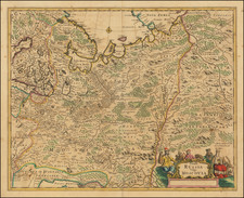
Decorative hand-colored example of Hessel Gerritsz's map of Russia, with the large inset of Moscow and plan of Archangelsckagoroda.
Hessel Gerritsz's map of Russia, first issued 1613, was published by Blaeu after he acquired the plate following Gerritsz's death in 1632. The top left corner has an inset plan of Moscow with a 17-point key. On the right is a prospect of Archangel, Russia's only northern port until the founding of St Petersburg in 1700. Three figures in Russian dress stand above. The title is within a martial cartouche.
The map was compiled from manuscript maps and work brought back by Isaac Massa. The inset plan of Moscow has been attributed to the Crown Prince Fydor Gudonov.
Willem Janszoon Blaeu (1571-1638) was a prominent Dutch geographer and publisher. Born the son of a herring merchant, Blaeu chose not fish but mathematics and astronomy for his focus. He studied with the famous Danish astronomer Tycho Brahe, with whom he honed his instrument and globe making skills. Blaeu set up shop in Amsterdam, where he sold instruments and globes, published maps, and edited the works of intellectuals like Descartes and Hugo Grotius. In 1635, he released his atlas, Theatrum Orbis Terrarum, sive, Atlas novus.
Willem died in 1638. He had two sons, Cornelis (1610-1648) and Joan (1596-1673). Joan trained as a lawyer, but joined his father’s business rather than practice. After his father’s death, the brothers took over their father’s shop and Joan took on his work as hydrographer to the Dutch East India Company. Later in life, Joan would modify and greatly expand his father’s Atlas novus, eventually releasing his masterpiece, the Atlas maior, between 1662 and 1672.
![[Poland] Mappa Geographica Poloniae, in partes suas majores, Austriae, Russie et Borussie. divisa in lucem pubicam . . . .](https://storage.googleapis.com/raremaps/img/small/60050.jpg)
![[ Holy Roman Empire, Poland, Baltic, etc. ] Germania VI Nova Tabula (First state!)](https://storage.googleapis.com/raremaps/img/small/94645.jpg)
![(Trans-Siberian Railroad) Карта путей сообшения Азиатской России [Map of Communication Routes of Asiatic Russia]](https://storage.googleapis.com/raremaps/img/small/93139.jpg)