


|
||

|

|
|

|
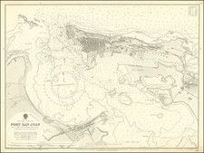
Rare Tomas Lopez pair of charts of Puerto Rico was published in Madrid.
The top chart depicts the waters surrounding San Juan with soundings and navigational hazards. A detailed plan of the city is given, with surrounding fortifications and a numbered key identifying 27 locations. The map is based upon a manuscript chart by Francisco Ramon Mendez, Primer Pilot of the Royal Spanish Armada. Mendez surveyed the area in December 1782 aboard one of the most famous Spanish War ships of the period, the San Juan Nepomuceno.
The lower chart depicts the western coastline of the island from Rincon to Cabo del Aguila, known as the Aguada Nueva. This chart was based on the work of Thomas Jefferys from his 1762 Plan of the Aguada Nueva de Puerto Rico.
Rarity
This is the first time we have ever offered the map for sale.

![Porto Rico and Virgin Islands [with] Haiti, Hispaniola or St. Domingo](https://storage.googleapis.com/raremaps/img/small/78402.jpg)