|
||

|

|
|

|
Rare map of the United States, extending from Coast to Coast, issued by F.W. Streit, in Leipzig. The big bend in the Rio Grande and a widened Panhandle that narrows at the 40th parallel and then shoots off northwest to north of Salt Lake. Keyed ocations for cities, villages, forts, Native American lands, universities, waterfalls, roads, etc. States and territories are numbered rather than named, and colored in outline to correspond to the key at top right. Streit, who served as an engineer in the Prussian artillery, was a mathematician and military cartographer. The detail in the Northwest and the listing of Indian Tribes is of particular note. Very detailed throughout the Northwest. A river connects SF Bay with the two Salt Lakes. The Cartography in California pre-Fremont. Double wide Arkansas. Oddly misshaped Michigan, Indiana, Ohio and Illinois, which is pushed off the Lake, as was the norm in the 1810s and 20s. Striking engraving style. One of the most detailed listings of western Indian Tribes of the period. A scarce map. Not in Wheat.

![[ Military Departments ] Johnson's New Military Map of the United States Forts, Military Posts & all the Military Divisions with Enlarged Plans of the Southern Harbors . . .](https://storage.googleapis.com/raremaps/img/small/101114.jpg)
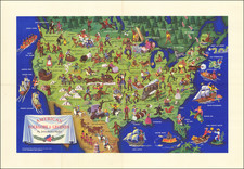
![[1958 World's Fair] The United States The Land of the People / Les Etats-Unis Le Pays et ses Habitants / De Verenigde Staten hed Land en het Volk](https://storage.googleapis.com/raremaps/img/small/76701.jpg)