|
||

|

|
|

|
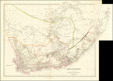
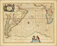
The First Locally Produced and Published Map of the whole of South Africa
Rare early map of South Africa, first published in Cape Town in 1857, by Henry Hall.
The present example is the second printing of the map by Edward Stanford, following Hall's sale of the engraving plates to Stanford in 1857. Stanford's map relied on the original engraving plates, adding a new title in Dutch and re-engraving Hall's original English title, but without changes to the map.
Hall's map was profoundly impactful in advancing the cartographic knowledge of South Africa. As noted by Liebenberg:
Disregarding the maps of Arrowsmith and Wyld, [Hall] painstakingly built his own cartographical database and in 1852 wrote to the Governor of the Cape Colony that he was almost ready to provide the country “with what hitherto has been so much required: a tolerably correct Map of South Africa”. His printed maps of 1856, 1857 and 1859 were cases in point and in 1857 Her Majesty’s Astronomer at the Cape, Sir Thomas Maclear, referred to Hall’s printed map of
South Africa as “beyond question, far in advance of any previous attempt”.
The map shows the "Boundary of British Colonies"; Boundary of Boer Republics"; African tribes; Betjuana, Hottentot races, Damaras, "Negro Races", missions stations, principal and smaller towns and villages, electoral divisions, districts, military posts, main roads, and the progress of the earliest railroads.
Mapping South Africa
The present map is the first map of South Africa entirely produced within the Colony. As noted in the Abstract to Elri LIebenberg's work on Henry Hall:
In 1857, [Henry] Hall became the first resident cartographer to publish a map of the entire African region south of 16°S. Entitled South Africa, this map was the first of its kind ever to be produced in South Africa as not only the compilation, but also the engraving, printing, colouring and mounting were undertaken locally. In 1859 Stanford’s published two additional maps, under Hall’s name: one of the subcontinent south of 25° 30’S entitled South Africa, and another entitled
Map of South Eastern Africa from Algoa to Delagoa Bay.In spite of Henry Hall’s rightful claim to fame as South Africa’s foremost pioneer cartographer, little has been published on his cartographical work. . .
Prior to 1830, the British Colonial Office in the Cape Colony had regularly complained of the lack of a comprehensive map of the Colony. In 1830, a Mr. Herbert was emloyed to create a large manuscript map of southern Africa, which was never published. "Herbert's Map" became the most important map of the reigon in the 1830s. The first printed map to incorporate Herbert's Map was John Arrowsmith's map of the Cape Colony in 1834, followed by James Wyld's map of South Africa in 1844.
Following Hall's arrival in South Africa, he benefitted from contacts with Surveyor General Charles Michell and Her Majesty's Astronomer at the Cape, Sir Thomas Maclear, who would have had access to the various regional surveys conducted in the Colony. By 1852, Hall's correspondence began to discuss his work on a map and his desire to obtain funding to have the map engraved. The first discussion of the publication of the map by Cape Colony Governor Sir George Grey was in April 1850, who noted that John Arrowsmith would "probably willingly undertake its publication." Arrowsmith expressed his willlingness to published the map in a letter to the Colonial Office dated November 14, 1851.
Publication by Arrowsmith was delayed for several years, resulting in Hall expressing his frustration to Arrowsmith and by January 1855, Governor Grey sent an ultimatum to Arrowsmith demanding publication. For reasons not known, Arrowsmith returned the Hall's unpublished map to the Cape Town, where is was engraved and published by J.A. Crew in Cape Town in 1857, at a cost of 125 pounds. As noted by Liebenberg:
What makes Hall’s map of 1857 of particular interest is that it is one of the earliest cartographical documents of southern Africa to include not only the newly found[ed] Boer republics of the Orange Free State (founded 1854) and the Transvaal (founded 1852), but also the routes followed by the mid-19th century explorers ) Orpen and Shelley (1852), Chapman (1854), Livingstone (1853 and 1856), C.J. Andersson (1853), Moffat and Edwards (1854), and Green and ahlberg (1856) during their explorations into the vast area north of 20° South. By including these routes on his map Hall extended the northern limit of his manuscript maps of 1849 and 1850 with 10° and therewith consciously moved into the unknown parts of southcentral Africa. Hall was a personal friend of almost all the above-mentioned explorers and a possible explanation for his bold decision is that he considered it his duty and obligation to make their geographical achievements known to the wider public.
* * *
Hall’s representation of the Orange Free State and Transvaal Republics comprised only the second printed map of these newly founded states, the first being a map by Hermann Berghaus published in the German periodical Petermanns Geographisches Mitteilungen of 1855. Equally interesting is the fact that Hall’s map is the first printed map on which the name “Pretoria”, the capital of the Republic and founded in 1855, appear. . .
* * *
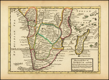
Soon after its publication in South Africa Hall sold the copyright of his map of 1857 to Stanford of London who used the existing plates to publish the complete map under both an English and a Dutch title. However, in 1859 Stanford transferred the area south of 25° S to a conical projection, re-engraved it and published another edition, slightly updated . . . Except for the area between 16° S and 26° S which was discarded, all detail on the original 1857 map was retained. Although the actual reason for doing away with the area north of 25 S is not clear, especially as the map border now cuts through the Transvaal, the decision was probably based on the scanty information that was available on these areas.
Rarity
The present map is extemely rare. OCLC locates one copy (University of Cape Town) and a copy at the University of Cambridge dated 1860 (?).
The following is excerpted from Eli Lienbenberg's paper on Henry Hall and his maps.
In 1828, the death of his father compelled him to seek work in order to support his financially embarrassed family.
In 1839, after having worked for a builders firm for nine years, Hall entered the Government Service as Foreman of Works in the Royal Engineer Department. His appointment was greatly promoted by the fact that he gained first place in a competitive examination with eighteen other candidates, and in 1842 he was ordered to the Cape Colony.
Hall served on the Eastern Frontier during the Frontier Wars of 1846 and 1851-52, first in Grahamstown and later in Fort Beaufort before moving back to Grahamstown. In 1852, Hll returned to England for health reasons where he was employed in the Office of the Inspector-General of Fortifications until he returned to Cape Town in 1853 at his own request.
In 1858 he was promoted to the rank of Clerk of Works of the first class after which his designation was “Clerk in charge of Royal Engineer Department”. In 1860, he was requested to finally return to England as the Cape was not considered a station for officers of his class.
During his stay in South Africa Hall contributed richly to the scientific and cultural life of the mid-nineteenth century Cape. As engineer he was actively involved in the erection of fortifications on the Eastern Frontier and in later years he supervised the building of several public buildings in Cape Town, amongst which the current South African Museum and National Library.
He was also a competent and avid writer who regularly contributed publications and translations of either a scientific or literary nature to the Eastern Province Monthly Magazine and the Cape Monthly Magazine. In June 1860, prior to his final departure from Cape Town, the Cape Parliament voted him a testimonial of £100 in recognition of his services to
public life in general.
Attached to the Portsmouth Royal Engineer Office for some time, he moved to London after his retirement where he died in 1882.