|
||

|

|
|

|
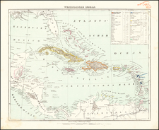
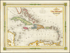
Fine, Rare Map of the Caribbean from a Curious Spanish Publication
Detailed map of the Caribbean from Juan Corradi's Descubrimiento y Conquista de la America o Compendio de la Historia General del Nuevo Mundo (1803). The maps for this book were created by a team of cartographers at Spain’s Dirección Hydrográfica, lending importance to an otherwise mundane publication.
Largely unknown until recent years, the map is extraordinarily well-researched for its date and context of illustrating an abridged and translated adaptation of William Robertson’ History of America (1777).
The map shows the entire Caribbean region, as well as part of the Pacific coast of Central America. The Gulf of Mexico is shown with shallows marked. New Orleans is prominently shown in Louisiana, as are settlements in Florida Territory such as Mobile (Movila) and Saint Augustine (S. Agustin).
All the landmasses have prominent rivers marked, a feature of all the Corradi maps; they are especially evident in Central America on this map, and radiating from Lago Maracaybo in South America.
While political and regional boundaries are marked with a dotted line, they are not the focus here. It is intended as a reference to readers who are learning the history of the Spanish Empire in the Americas.
Sources for this map include the “Carta Esférica que Comprehende Las Costas Del Seno Mexicano…,” published in Madrid in 1799 by the Depósito Hidrográfico, an institution related to the Dirección. That chart, seen here, is generally regarded as the most important Spanish charting of the Gulf of Mexico in the eighteenth century.
The publication of the Corradi maps
This map was one of three that appeared in Juan Corradi’s translation of Joachin Heinrich Campe’s adaptation of William Robertson’s History of America (1777). The latter was a hugely popular work that was translated, reprinted, pirated, and adapted dozens of times across Europe in the late-eighteenth and nineteenth centuries.
Corradi translated Campe’s German work into a three-volume Spanish set. Rather than reuse existing maps, or adapt Kitchin’s maps made for Robertson into Spanish, Corradi instead acquired amazingly detailed maps for each volume.
- Vol. 1 focuses on the voyages of Columbus and has this map.
- Vol. 2 discusses the expeditions of Hernán Cortes and has this map, “Carta Esferica Del Reyno De Mexico y parte de la America Setentrional.”
- Vol. 3 focuses on Pizarro, with a map of South America
While Corradi’s connection to Spain’s hydrographic body, the Dirección, is not clear, it is known who worked on these maps. Under Carlos III (r. 1759-1788), the centuries-old policy of tightly controlling Spain’s geographic knowledge lifted somewhat. It was under Carlos III’s orders that the Dirección was organized, with the initial guidance of Vincent Tofino.
While Carlos III’s son, Carlos IV (r. 1788-1808), returned Spain to a tighter regulation of cartographic content, this map, with its expert makers, did not attract scrutiny. It was produced by Dirección hydrographers Tomás Gonzalez, José María Cardano, Felipe Cardano, and Juan Morata. The Cardanos were the engravers, Morata a draughtsman, and Gonzalez a geographic compiler. This cartographic dream team lent prestige to an otherwise unremarkable publication.
Rarity
The Corradi maps are quite rare on the market. This is the first time we have offered this map in over twenty years.