|
||

|

|
|

|
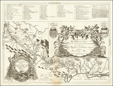
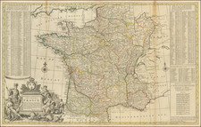
Very detailed and exceptionally scarce map of the American supply lines in France during the First World War.
That map was made by Bert L. Baldwin "Late Major of Engineers" in the American Expeditionary Service, Service of Supply Division.
The lines of supply stretch across France from the Atlantic Coast underneath Brittany (St. Nazaire, La Rochelle, and Bordeaux) to the American front at Alsace-Loraine. The railroads are differentiated between those "operated by A.E.F" and "Connecting French Railroads".
On 25 June 1917, the first US troops began to arrive in France, forming the American Expeditionary Force. However, the American units did not enter the trenches in divisional strength until October. The incoming troops required training and equipment before they could join in the effort, and for several months American units were relegated to support efforts. In spite of this, however, their presence provided a much-needed boost to Allied morale, with the promise of further reinforcements that could tip the manpower balance towards the Allies.
There are numerous annotations on the map listing, for instance, "Ship Berths" at A.E.F. ports on the Atlantic Coast of France. In 1917 there were a total of 23, in 1918 there were 89, and in 1919 there were 160. A long note in the south of France records covered storage and other logistics statistics.
Tours is noted as the headquarters of the S.O.S, and Chaumont has a star noting the general headquarters of the A.E.F. An area south of there is shaded as a "Training Area".