This item has been sold, but you can enter your email address to be notified if another example becomes available.


|
||

|

|
|

|
Stock# 62188
Description
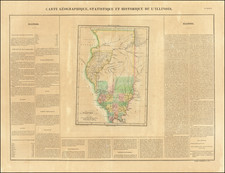
Highly detailed map of Illinois, published by the General Land Office.
Shows county boundaries and railroad land-grant limits are shown in color. Also shows county names, public land surveys, towns, principal railroad stations, canals, railroad lines, and physical features.
Condition Description
Minor discoloration along one fold


![[ Auburn Park / Chicago ] Eggleston, Mallette & Brownell's Property](https://storage.googleapis.com/raremaps/img/small/57703.jpg)