|
||

|

|
|

|
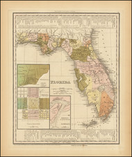
Second Seminole War Edition of Tanner's Map of Florida Territory
Gorgeous example of this rare 1836 state of Tanner's Map of Florida.
Tanner's first map of Florida is one of the earliest obtainable maps of Florida Territory. The first edition of the map is virtually identical to Charles Vignole's map of 1823, with the only difference being the lack of Vignole's name on the map. First issued in 1823, the second state of the map shows the addition of Gadsden County, whereas only St. Johns, Duval, Jackson and Escambia counties are shown in the 1823 edition.
This 1836 edition shows significant changes, many of which related to the Second Seminole War. The original St. Johns County in the south is now subdivided into Monroe, Mosquito, Hillsboro, Dade, and Alachua Counties, with a massive area in the center (yellow) called Mackley's, in what was then largely unexplored parts of Hillsboro County, including Miranda's Grant, Ft. Alabama, Fort King, Dade's Battle Ground, Camp Chisolm, Pilaklakaha Village, Chichuchaty and Ft. Cooper.
Richard Hackley's Grant
The map also shows "Mackley's". Mackley is a reference to Richard Hackley, a U.S. diplomat. Hackley purchased approximately 11 Million acres of Florida land from the Duke of Alagon’s land grant on May 29, 1819. However, the duke didn’t own the land at the time. Hackley’s purchase came as the U.S. was negotiating the purchase of East and West Florida from the Spanish government. During the negotiations with Spain, Several Americans tried to purchase large sections of Florida land. It prompted American officials to request a proclamation from the King of Spain to declare all grants and land purchases void if made after a certain date. Hackley’s purchase came after the date, so his purchase was voided.
In 1823, Hackley either did not know or did not care about the status of his land grant. Hackley arrived on the banks of the Hillsborough River and cleared some land on the eastern side in what is now downtown Tampa. In January 1824, Lt. Colonel George Mercer Brooke arrived with more than 100 U.S. infantry soldiers to establish what soon became known as Fort Brooke. Brooke moved into the structure Hackley built as his homestead. Hackley came back to his settlement and found it had become an army fort. Hackley sued the federal government, as did his heirs at different points over the next 80 years.
The war department decommissioning Fort Brooke in 1883 likely prompted the last round of lawsuits. Four families made claims. Many others attempted to just settle on the property and claim squatters' right. The US Supreme Court finally ruled against the Homesteaders and in favor of the U.S. Government's claim the Hackley's and others claims were voided.
Rarity
A rare edition of the map, timed to coincide with the Second Seminole War.

![[Pensacola] Piano del Porto, e degli Stabilimenti di Pensacola](https://storage.googleapis.com/raremaps/img/small/89465.jpg)