


|
||

|

|
|

|
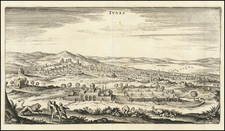
The Only Known Example -- The Fort/Citadel of Goletta Prior to the Turkish Siege of Tunis in 1574.
The engraving depicts the Bay of Tunis, apparently just before the siege by the Turks in July 1574 at the Goletta citadel. The Turkish expedition, supported by forces Maghreb Muslims, would permanently eliminate the Spanish presence in Tunisia.
Unlike a later state of the map which was previously known to exist, Bifolco opines in a recent update to his work that his a unique and previously unknown early state of the map, pre-dating the appearance of any information regarding the siege in July 1574, which is shown on the other known examples.
This map is attributed to Antonio Lafreri's printing house, due to the presence in the 1573 catalog of “Diuerse carte di Tunisi et la Goletta”. In Stefano Duchetti's inventory it is referred to as "Il forte de Tunis", while in Pietro de Nobili's as "Plan of the fortress of Tunis".
Siege of Tunis
In 1573, King John of Austria recaptured Tunis and Goletta, leaving Tunis with a garrison of 8,000 soldiers, under the command of Serbelloni. A decision was made to build a fortress in Tunis and improved the fortifications of Goletta The two fortresses, however, were reconquered by the Turks in August 1574, after a month of siege. Serbelloni himself was taken prisoner and taken to Constantinople.
In 1575, after his imprisonment, he wrote an account of his time at Goletta and Tunis, which was published in 1577 in the collection edited by Girolamo Ruscelli.
Rarity
Bifolco notes that this example is apparently the only known surviving example of the map.
Antonio Lafreri (1512-1577) (also known as Antoine Lafréry and Antoine du Pérac Lafréry) was a French mapmaker, engraver, and publisher who worked in Italy. Lafreri was born in Franche-Comté and moved to Rome around 1540. Lafreri sold sheet maps but he also bound maps into books for his clients based on their interests and needs. These are the famous Lafreri atlases, important pre-cursors to the modern atlas. He also published well known works such as the Speculum Romanae Magnificentiae (ca. 1575), a collection of engraved views and images of Rome. Lafreri was well-connected to the cartographic networks of the time, collaborating with Giacomo Gastaldi, Battista Agnese, Antonio Salamanca, Donato Bertelli, Paolo Forlani, and others.
![Tabula Aphricae II [Sicily & Sardinia shown]](https://storage.googleapis.com/raremaps/img/small/89727.jpg)
![Questo e Il vero disegno de Tunis con gran parte de lafrica tratto da un disegno fatto al tempo che Il Serenissimo Imperator Carlo V lo prese lan[n]o 1535 co[n] le distancie delle terre piu Jmportante.](https://storage.googleapis.com/raremaps/img/small/61570sb.jpg)
![Africa Minor Nova Tabula [shows Malta]](https://storage.googleapis.com/raremaps/img/small/59626.jpg)