


|
||

|

|
|

|
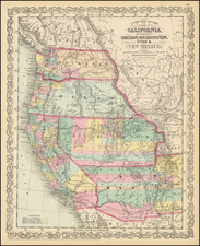
Rare state of Charles Desilver's map of the West, being the first state to identify the "Proposed Arizona Territory."
From 1846-1851, Mitchell and later Thomas Cowperthwait & Co., used the same basic copper plate for the map of Oregon & Upper California, updating the information and later the title on at least an annual basis. In this second state of the map, 2 degrees of the Pacific have been removed and the map shifted east two degrees, to show more of the course of the Yellowstone River, and the regions just east of the Rocky Mountains. The early errors have been corrected and the cartography continues to improve.
This is also the first edition to attempt to show the modern counties in Nevada and Arizona, rather than the county formations stretching horizontally across Utah and New Mexico Territories.
Many new trails are added, including Fremont's trails, Kearney, Col Cooke, etc. The Spanish or Los Angeles Route, Oregon Trail and Lewis & Clark Canoe Routes, are still shown. The Gadsden Purchase is now shown, as is the difference between Bartlett's line and Graham's Line, just east of Tucson, which is part of Mexico. Only Tulare and San Bernardino County are now shown, as are Skamania and Walla Walla Counties, east of the Cascades in Washington.
A nice example of this scarce map.
![[ Wyoming Oil Map -- Great Western Petroleum Co. ] Clason's Sketch Map of Wyoming (with prospectus and subscription)](https://storage.googleapis.com/raremaps/img/small/97810.jpg)