


|
||

|

|
|

|
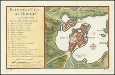
Rare French edition of Sayer & Bennett's rare chart of Boston Harbor revised and issued in Le Rouge's Pilote Americain Septentrionale, which was compiled specifically for use by the French Navy during the American Revolution.
A note following the title indicates that the chart was based on British surveys. The map is drawn from Sayer & Bennett's map of 1776, depicting Boston Harbor from roughly Deer Island to Hull. The map includes extensive soundings, the Harbor's many hazards are marked, and specific courses and sailing directions are provided for navigating the difficult waters. For example, accessing the "best channel" for the final approach to Boston requires one to sight on the "Charlestown Tree" situated on or near Breed's Hill. On land, there is a full street plan of Boston with several landmarks indicated, while the towns of Dorchester, Milton, and Hull are shown schematically. To the northwest are the "Ruins of Charlestown," indicating that the chart was completed sometime after the June 1775 Battle of Bunker Hill.
The Le Rouge edition is better-engraved than the Sayer & Bennett edition and rarer on the market.
George-Louis Le Rouge (1712-1790), though known for his work in Paris, was originally born Georg Ludwig of Hanover, Germany. He grew up and was educated in Hanover, after which he became a surveyor and military engineer. Around 1740, however, Le Rouge moved to Paris and set up shop as an engraver and publisher on the Rue des Grands Augustins. It was at this time that he changed his name, adopting a French pseudonym that would later become quite famous.
Le Rouge spent much of his forty-year career translating various works from English to French, and his cartographic influence often came from English maps. His experience as a surveyor and engineer in Germany made him a skilled and prolific cartographer, and he produced thousands of charts, maps, atlases, and plans. His work spans from garden views and small-town plans to huge, multiple-continent maps. Le Rouge eventually accepted the position of Geographical Engineer for Louid XV, the King of France.
Later in life, Le Rouge became well-known for publishing North American maps, such as in his Atlas ameriquain septentrional of 1778. One of Le Rouge’s other more famous works is the Franklin/Folger chart of the Gulf Stream, which he worked on with Benjamin Franklin. Franklin and Le Rouge corresponded around 1780 and collaborated to create this map, a French version of Franklin’s famous chart which was originally printed in 1769.
![[ Bunker Hill ] A Plan of the Action at Bunkers Hill on the 17th of June 1775 between His Majesty's Troops, Under the Command of Major General Howe, and the American Forces . . .](https://storage.googleapis.com/raremaps/img/small/70223.jpg)
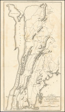
![[Long Island Sound from Hampstead Bay to Huntington Bay]](https://storage.googleapis.com/raremaps/img/small/51310.jpg)