|
||

|

|
|

|
Framing the Maine-Canada Boundary Dispute
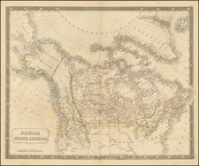
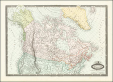
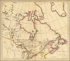
The first printed map to accurately highlight the disputed region between the United States and Canada, which would finally be resolved in August 1842, with the signing of the Webster-Ashburton Treaty, settling the so-called Aroostook War.
This fascinating map depicts the Canada-U.S. borderland from Lake Champlain to the Bay of Fundy, and shows the region of the Maine-Canada boundary dispute compiled by William Henderson and engraved by Hudson River School artist James Smillie. Henderson's work in compiling information and illustrating the regions impacted and the nature of the dispute is quite remarkable. The boundaries claimed by Canada and by the US are clearly delineated, along with proposed county boundaries for Cornwallis and Gaspe Counties.
he map was separately issued, as a means of illustrating a report in the Quebec Legislative Report in 1827 outlining the dispute. As noted by Henderson at the top left:
As this Sketch has been hastily compiled for the sole purpose of exhibiting the Geographical & Political importance of the Territory in question, Topographical accuracy in minor details has not been much attended to. The Head-waters of the Rivers. St. John and Etchemin & du Sud are laid down from actual Surveys by Mr. Ware and myself, the remaining parts from the most recent & approved authorities and more particularly Col. Bouchette's valuable work. April 1827.
Below the legend, the map sets out information concerning the area impacted by the dispute. Henderson's annotations are quite remarkable.
A scarce map depicting the Maine-Canada boundary dispute.
This fascinating map depicts the Canada-U.S. borderland from Lake Champlain to the Bay of Fundy, and shows the region of the Maine-Canada boundary dispute.
Maine-Canada Boundary Dispute
The boundary dispute between the American state of Maine and the British colonial provinces of New Brunswick and Lower Canada (Quebec) was one of the longest running and most acrimonious disagreements between the two nations. The origin of the dispute was found in the wording of the Treaty of Paris (1783), which concluded the American Revolutionary War and established the boundaries between the newly independent United States and what remained of British North America. The negotiators of the Treaty relied on outdated cartography, notably John Mitchell's A Map of the British and French Dominions in North America (1755), and so had a flawed understanding of the geography of the projected boundary, especially where it was to run through the interior.
The Treaty ordained that the northern section of the boundary between Maine and British territory was to run from where Quebec's boundary ended at the 45th parrellel "along the height of land" to the St. John River. While the Maine-New Brunswick boundary had been resolved from Passamaquoddy Bay up northwards to near where the Aroostook River enters the St. John River, in 1797, the boundary beyond that further to the north remained in dispute. The British claimed that the "height of land" ran along the crest of the Appalachians, so claiming a large chunk of what Maine considered to be its territory. The Americans countered that the boundary should run along the height of land dividing the watersheds of the St. Lawrence River and the Gulf of Maine, so passing the border dangerously near the St. Lawrence River, Canada's lifeline. The American claim, if implemented, would also make it difficult for the British to build an all-season road between Quebec City and the St. John Valley, as at least half of the Upper St. John region had to be secured to provide a viable route.
Unable to resolve the issue themselves, in 1831, the Americans and the British submitted their dueling claims to King Willem I of the Netherlands for non-binding arbitration. Willem duly proposed a compromise, which the British rejected outright, as it heavily favored the Americans. The situation remained tense, with officials and lumberjacks from each side almost coming into armed conflict in 1838 and 1839, in what was exaggeratedly known as the 'Aroostook War' (1838-39), in which several British were captured; no one was killed, but two Canadian militiamen were injured by black bears.
The governments in both Washington and London were alarmed by the Aroostook incidents and mutually wanted to resolve the boundary dispute, once and for all, so as to avoid a diplomatic catastrophe sparked by hot-headed local residents. In 1842, U.S. Secretary of State Daniel Webster met with the British Minister to the U.S., Alexander Baring, 1st Baron Ashburton, to resolve the matter. Ashburton was under pressure to ensure that the British were granted enough of the Upper St. John so as to build the Quebec-New Brunswick road, while Webster had an embarrasing problem to resolve. The U.S. Army had recently constructed a massive brick fortress on the Richelieu River, Fort Montgomery, supposedly just south of the U.S.-Quebec line (the 45th parallel). However, recent surveys had shown that the 45th parallel and the international boundary actually ran to the south of the fort. Webster was determined to rescue what became known as "Fort Blunder", by having the U.S.-Quebec boundary moved north a touch, and in return he was prepared to concede more territory in Maine to the British, enough for them to comfortably build their road. Fortunately, in this Treaty both sides received what they really needed and both sides saved face.
In the immediate wake of the Treaty, 3 different London publishers came out with versions of the map depicting the boundary resolution, each with the same title. The most common of these was by John Wyld, issued with a pamphlet, George Featherstonhaugh's Observations upon the Treaty of Washington (1843), while another version was published by Her Majesty's Printing Office with the British government's official printing of the text of the treaty.
Rarity
The map is very rare. OCLC locates copies at Laval University, McCord Museum, National Gallery of Canada and the Canadian National Archives.
James D. Smillie and the Smillie family members were active in New York City and the New England area as engravers and landscape painters during the nineteenth century.
Members of the Smillie Family of artists include James Smillie (1807-1885), his sons James D. (1833-1909) and George Smillie (1854-1924), and George's wife Helen 'Nellie' Jacobs Smillie (1855-1926).
James (Senior) was born in Edinburgh, Scotland to David and Elizabeth Smillie. James Smillie immigrated to Quebec, Canada. James must have learned engraving from his father who worked with jewelry and silver. Upon his father's death in 1827, Smillie travelled to London and eventually to New York City, where he embarked on a career of creating engravings of paintings by other artists.
By 1831, James had established his reputation primarily as an engraver of American landscape paintings. The portability of James Smillie's engravings helped to bring to the American public the grand landscapes by Albert Bierstadt, Thomas Cole, and Asher Durand. Smillie also worked for the American Banknote Company.
James Smillie married Catherine Van Valkenburg in 1832, and two of their sons, James David and George Henry also became artists. Elder son James D. assisted his father with engraving and later explored his own artistic talents in prints of the American landscape. Among his many subjects were the Sierra Nevada, Adirondack, Rocky, White, and Catskill Mountains. James D. Smillie was a founding member of the American Watercolor Society and served as its president from 1873 to 1879. Additionally, he was an early member of the New York Etching Club and the first meeting was held in his studio in 1877. James D. also wrote about art for various periodicals.
Like his older brother, George Henry Smillie learned engraving from his father, but turned to painting early in his career. By 1862, he had his own studio in New York City and exhibited with the National Academy of Design in 1864. George travelled throughout the United States sketching and painting landscapes inspired by Long Island, the Adirondack Mountains, the Rocky Mountains, and New England. Many of George's paintings of the American West were influenced by the Hudson River School. George married one of his brother's pupils, Helen Sheldon Jacobs.
Helen Jacobs Smillie, known as Nellie, was born in New York City to Samuel and Helen Jacobs. She received art instruction at Cooper Union and the National Academy of Design and was a pupil of James D. Smillie and J. O. Eaton. She married George Smillie in 1881, with whom she had three sons, Sheldon, Charles, and Gordon. Nellie was a member of the American Watercolor Society along with her husband and brother-in-law, and painted in the Hudson River School style.
![[First State of the Popple Key Sheet] A Map of the British Empire in America with the French and Spanish Settlements adjacent thereto by Hen. Popple.](https://storage.googleapis.com/raremaps/img/small/92714.jpg)