|
||

|

|
|

|
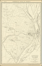
Important Early Antique Map of the Platte Country -- Published in St. Louis
Finely executed map illustrating the lands transferred to the United States under the Platte Purchase.
A note at the top discusses the establishment of the border with Iowa, approved by the legislature on December 21, 1836, commissioners including Daniel M. Boone, Elias Barcroft and Stephen Cooper, with Joseph C. Brown serving as Engineer.
A note below the title states that the East Boundary
was first surveyed as an Indian boundary line in 1861 by John C. Sullivan, as principal surveyor, & Saml. K. Caldwell as assistant Surveyor under the authority of a letter from William Rector . . . dated July 23rd, 1816 . . .
The Road from Liberty to Council Bluffs crosses the map horizontally.
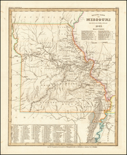
The Platte Purchase was a land acquisition in 1836 by the United States government from American Indian tribes. It comprised lands along the east bank of the Missouri River and added 3,149 square miles to the northwest corner of the state of Missouri.
This expansion of the slave state of Missouri was in violation of the Missouri Compromise of 1820, which prohibited the extension of slavery in the former Louisiana Territory north of the parallel 36°30′ north except within the boundaries of the state of Missouri as defined at the time of the adoption of the Missouri Compromise. The area acquired xtended Missouri westward along the river. St. Joseph, one of the main ports of departure for the westward migration of American pioneers, was located in the new acquisition.
The region of the Platte Purchase includes the following modern counties within its bounds: Andrew, Atchison, Buchanan, Holt, Nodaway, and Platte. It also includes the northwest suburbs of Kansas City, a small area of Kansas City proper, the cities of St. Joseph and Maryville, Missouri.
When Missouri entered the Union, its western border was established on the left bank of the Missouri River at the mouth of the Kaw River in Kansas City. The acquisition challenged the Missouri Compromise of 1820 by expanding slavery into free territory north of the southern Missouri border with Arkansas, as well as the Indian Removal Act of 1830 in which tribes had just been moved west of the Missouri border "in perpetuity" as part of the painful Trail of Tears process.
In less than a year after the Indian Removal Act, the Missouri General Assembly was petitioning Congress to more clearly define the border on the northwest corner of the state. The Legislature noted the boundary was not clear, and that the land was not surveyed, thus leading to settlers encroaching on the lands. The most spectacular example of encroachment was Joseph Robidoux who had been operating an American Fur Company trading post at St. Joseph, Missouri since 1826.
On January 27, 1835, Senator Lewis F. Linn wrote John Dougherty, an Indian agent, to inquire about acquiring the land. Dougherty agreed, noting that the territory was preventing access to Missouri River shipping by Missouri residents east of the purchase line. The first tribes to give up their land were the Potawatomi, who gave up their land in the Treaty of Chicago. The formal application came in the summer of 1835 when at a meeting on the Dawes farm near Liberty, Missouri, where the Indian agent for the Sac and Fox tribes, Andrew S. Hughes, presided over a meeting of Missouri residents who formally asked Congress to acquire the land. Missouri senator Thomas Hart Benton introduced a bill to acquire the land and it was approved with little opposition in June 1836.
An agreement was reached in 1836 with the chiefs Mahaska and No Heart of the Ioway tribe and leaders of the combined Sac and Fox tribes in a ceremony at Fort Leavenworth, Kansas that was presided by William Clark, then the Superintendent of Indian Affairs and based in St. Louis.
The U.S. Government set up a General Land Office in Plattsburg, Missouri to handlesettlement. Much of the land was dispensed as military land warrants to veterans of the War of 1812 (and later Mexican–American War). Under the terms of the program, which was expanded in 1855, the 160-acre land grants could be given to military descendants and those grants could be sold.
Initial settlement was concentrated in the south in the Platte County area. Almost overnight, Platte County became the second largest county in the state and Weston, Missouri ("West Town") was second only to St. Louis, Missouri in the state. St. Joseph would subsequently became the second largest city in the state in the early settlement days. Since the purchase opened up a new slave area, the area was heavily settled by slaveholders from Virginia, Tennessee and Kentucky. Southern crops that were slave intensive such as hemp and tobacco were grown in the southern portion. The settlement of the northern portion had fewer Southern settlers and slaves.
Rarity
The map is believed to survive in two known examples, (Library of Congress and Newberry Library/ex-Graff Collection), although we note a copy listed in OCLC in the Missouri State Historical Society.