|
||

|

|
|

|
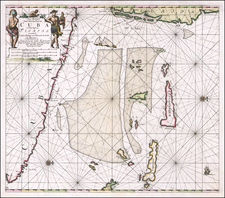
Antique Sea Chart of South Florida, the Florida Keys and the Bahamas
Rare mid 19th Century French Sea Chart of Florida and the Bahamas, based upon Edmund Blunt's 1847 chart The Bahama Banks and Gulf of Florida, which covers a significantly broader area. The present chart is on a larger scale and more focused on the region covered by the map.
The chart provides a remarkable treatment of the Florida Keys and extends from Baie De San Carlos on Florida's West Coast and Ile Hutchinson on the East Coast to Grand Abaco and Golfe D'Exuma and Providence (and the Northern coast of Cuba).
Place names in Florida include Fort Lauderdale, Fort Dallas, Fort Jupiter
Extensive details, including soundings and approximately 15 coastal views.
Rarity
The chart is apparently very rare. We are not aware of any other examples appearing at auction or in dealer catalogs.
OCLC locates 1 copy of the 1852 edition of the map (British Library) and no copies of this 1851 edition or any other edition of the map.
The Dépôt de la Marine, known more formally as the Dépôt des cartes et plans de la Marine, was the central charting institution of France. The centralization of hydrography in France began in earnest when Jean-Baptiste Colbert became First Minister of France in 1661. Under his watch, the first Royal School of Hydrography began operating, as did the first survey of France’s coasts (1670-1689). In 1680, Colbert consolidated various collections of charts and memoirs into a single assemblage, forming the core of sources for what would become the Dépôt.
The Dépôt itself began as the central deposit of charts for the French Navy. In 1720, the Navy consolidated its collection with those government materials covering the colonies, creating a single large repository of navigation. By 1737, the Dépôt was creating its own original charts and, from 1750, they participated in scientific expeditions to determine the accurate calculation of longitude.
In 1773, the Dépôt received a monopoly over the composition, production, and distribution of navigational materials, solidifying their place as the main producer of geographic knowledge in France. Dépôt-approved charts were distributed to official warehouses in port cities and sold by authorized merchants. The charts were of the highest quality, as many of France’s premier mapmakers worked at the Dépôt in the eighteenth century, including Philippe Bauche, Jacques-Nicolas Bellin, Rigobert Bonne, Jean Nicolas Buache, and Charles-François Beautemps-Beaupré.
The Dépôt continued to operate until 1886, when it became the Naval Hydrographic Service. In 1971, it changed names again, this time to the Naval and Oceanographic Service (SHOM). Although its name has changed, its purpose is largely the same, to provide high quality cartographic and scientific information to the France’s Navy and merchant marine.
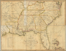
![(Coast of Florida, Georgia and the Carolinas] [To The Members Of The Nautical Institution And Ship-Masters' Society Of The City Of New York, This Chart, Extending From Lat. 40°15 N., Long. 72°15 W., to Lat. 22°35 N., Long. 80°25 W., Is Respectfully Dedicated / By Their Obedient Servant Edmund M. Blunt]](https://storage.googleapis.com/raremaps/img/small/77294.jpg)