
This item has been sold, but you can enter your email address to be notified if another example becomes available.


|
||

|

|
|

|
Stock# 60820
Description
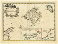
Antique Map of Mallorca with 34 City Views
Rare map of Mallorca, published in Palma in about 1830.
Finely detailed map of the islands of Mallorca, Cabrera and Conejera. The map is based upon a rare 4 sheet map published in 1785 by Julián Ballester, at the request of Cardinal Don Antonio Despuig, and engraved by Joseph Muntaner on a scale. While other publishers also copied the map, this would seem to be the only edition of the map which also copied the town views.
Although dated 1814, the map includes census data from 1829. The map is surrounded by views of all the towns of the island, each with a brief description of the population with agricultural data, statistics, etc.
Likely published during Reign of Fernando VIII (1803-1833)
Condition Description
Dissected and laid on linen, as issued.
![L. Rouwolfs Reys-Togten, door de Levant, of Oosterse Landschappen der Middellandse Zee [shows Cyprus]](https://storage.googleapis.com/raremaps/img/small/83622.jpg)