


|
||

|

|
|

|
Monumental Brazilian Wall Map from the War of the Triple Alliance
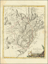
Remarkable map of Paraguay prepared by the Brazilian Military in Rio de Janeiro during the War of the Triple Alliance. The large map shows the major campaigns which led to a Brazilian/Argentine/Uruguayan victory and the destruction of Paraguay’s economy and army.
The title of the map reads:
Carta do territorio da Republica do Paraguay, onde se derão as batalhas entre o exercito desta Republica e os das naçōes alliadas, Imperio do Brazil, Confederação Argentina e Republica do Uruguay, desde 1866 até 1870; confeccionada por proposta approvada por avizo do Ministerio da Guerra de 3 de setembro de 1869, do Commandante Geral do Corpo de Engenheiros, Marechal de Campo, Conselheiro de Guerra Antonio Nunes de Aguiar, pelos officiaes empregados no Archivo Militar.
Translation: Map of the territory of the Republic of Paraguay, showing the battles between the Army of this Republic and those of the allied nations, the Empire of Brazil, the Confederation of Argentina and the Republic of Uruguay, from 1866 to 1870; prepared by a proposal approved by the Ministry of War on September 3, 1869, of the Commandant General of the Corps of Engineers, Field Marshal, War Adviser Antonio Nunes de Aguiar, by the officers employed in the Military Archive.
This map, then, can be seen as the official Brazilian record of a war that they ultimately won. It was printed by the Lithography Office of the Military Archive. As the title explains, it was based on new information gathered by the Brazilian Army during the war and the most up-to-date foreign maps available in the Military Archive’s collection.
The map shows a detailed rendering of the topography of the region. Rivers, lakes, roads, and settlements, particularly Jesuit missions, are carefully labeled. Dotted lines show the various marches undertaken by armies during the war, but perhaps the most distinct features of the map are the tiny crossed swords that dot the terrain.
These swords, and their corresponding numbers, mark the battle sites where Paraguayans clashed with allied forces in the War of the Triple Alliance. These battles are listed chronologically in a legend to the left, just below the title. They date from between April 10, 1866 and March 1, 1870.
The War of the Triple Alliance
The War of the Triple Alliance, also known as the Paraguayan War or, in Paraguay, the Great War, was the bloodiest inter-state conflict ever to take place in Latin America. While estimates vary and cause considerable contention, it is thought that 60%, and possibly more, of Paraguay’s population was wiped out. The hundreds of thousands of men who lived in Paraguay prior to the war were reduced to only 28,000, as much as a 90% loss.
Border disputes in the region were nothing new by the 1860s. Spain and Portugal had fought over the precise location of the frontier between their empires since the fifteenth century. After the Latin American states gained their independence in the early nineteenth century, the new nations inherited the disputes that concentrated in the Rio de la Plata basin, which is where Paraguay, Uruguay, Brazil, and Argentina all converge.
A catalyst for the War of the Triple Alliance was Brazil’s interference in a Uruguayan civil war in 1864. Emperor Pedro II wanted to ensure that his preferred Colorado Party prevailed; with Brazilian aid they did and the Colorados continued to rule Uruguayan politics uninterrupted until the 1950s. Paraguay’s leader, Francisco Solano López, had supported the other contender, the Blanco Party, and saw Brazil’s interference as a dangerous precedent that undermined Paraguayan sovereignty and the regional balance of power.
López’s father, Carlos Antonio López, had begun Paraguay’s accelerated industrialization in the decades prior to the war. Paraguay had one of the first railways in South America and revenue came from a shipyard and a large foundry. At the time, the only way for freight and people to travel south from Brazil was to navigate the Paraguay River, further enhancing the nation’s importance.
In response to the Brazilian aggression in Uruguay, López threatened to unleash his army, which, thanks to conscription, included every man of fighting age in Paraguay. When Pedro II did not back down, López attacked Mato Grosso, to the north of the area shown on this map. On May 1, 1865, the president of Argentina, Bartolomé Mitre, signed an alliance consisting of Brazil, Argentina, and Uruguay, which was now controlled by the Colorados. These three combatants formed the eponymous Triple Alliance.
Although the alliance outnumbered Paraguay’s population 25 to 1, López had amassed a powerful, if antiquely provisioned, army. In 1865, López’s forces made early gains. They advanced in both Uruguay and Brazil, but soon had to withdraw due to logistical problems and the amassing of the Allied Army. In June of that year, the Brazilian Navy defeated the Paraguayans at Riachuelo, opening the way for a blockade of Paraguay’s rivers. The landlocked country was now cut off from the outside world.
López and the Paraguayan army did not surrender, however. Instead, they entrenched themselves and expanded the draft to include all men, leaving few to work the fields and causing many to starve. It is during this period, 1866-70, that the battles listed on this map took place. Farther south, in 1868, the allied troops under the Brazilian marquês de Caxias, took the crucial fortifications at Humaitá; this opened the way to the capital, Asunción.
In December of 1868, at the Battle of Lomas Valentinas near Asunción, the balance of the Paraguayan army was defeated. This is battle 34 listed in the legend to the left. López fled north, where he would be killed at the Battle of Cerro Cará on March 1, 1870. This is the final battle included on the map, number 50.
Paraguay was utterly devastated by the war—politically, economically, and demographically. The country lost territory to Brazil and Argentina. The allies continued to occupy the country until 1876 and levied a large indemnity on the nation (which was never paid). Even today, Paraguayan politics and economics refer to and are impacted by the outcome of the War of the Triple Alliance.
Rarity
This map is extremely rare. OCLC locates only the example in the National Library of Spain. We also note a copy referenced in Philips (Checklist of Large Scale Maps Published by Foreign Governments, p. 55 Library of Congress, 1904).
Provenance
The map was originally acquired by the French Embassy at the Palais Beauvryé in Berlin, as noted by the elaborate contemporary manuscript note on the verso (Department des Affaires Etrangeres de l'Empir Germanique a Berlin). Thereafter, several stamps reflect ownership by German archives. Quite likely, the map was in the French Foreign Office during the time Count Vincent Benedetti (1817-1900) was serving as French Ambassador to Prussia. The map probably remained there until the outbreak of the Franco-Prussian War in 1870.
The collection from which the map came was likely resident in East Germany after World War II.
![Carte Du Paraguay . . . [showing Rio Janeiro, Buenos Aires, Salta, etc]](https://storage.googleapis.com/raremaps/img/small/101636.jpg)
![[ Peru and Upper Peru ] Carte Du Perou et Du Haut Perou…1829](https://storage.googleapis.com/raremaps/img/small/98834.jpg)