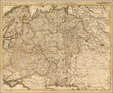
Attractive Russian-Language Map of Russia, from the World War I Era.
Antique map of European Russia, published in Petrograd (Saint Petersburg) between 1914 and 1917.
The map was published by the Alexey Iliyn Cartograph Institute, which was named after one of Imperial Russia's great 19th-century cartographers.
The map can be dated by its use of "Petrograd" rather than "Saint Petersburg", a convention adopted by the Russians to de-Germanize the city after the start of World War I. It carried this name from 1914 until it was renamed Leningrad in 1924.
Alexey Afinogenovich Ilyin (1832–1889) was a distinguished Russian cartographer, military officer, and map publisher, best known for founding A. Ilyin’s Cartographic Establishment, which became one of the most prominent cartographic enterprises in Imperial Russia.
Born in Shlisselburg, Leningrad Oblast, Ilyin began his career as a General Staff officer, where he served as a cartographer for the Military Topographic Depot. His military career was marked by his steady rise to the rank of lieutenant-general, a position that granted him privileged access to government map archives, a significant advantage for his later cartographic work.
In 1859, Ilyin partnered with fellow General Staff officer Vladimir Poltoratsky to establish a publishing firm in St. Petersburg, originally known as the Chromolithography of Poltoratsky, Ilyin, and Co.. Specializing in lithographic printing and cartographic products, the firm quickly gained a reputation for high-quality maps and atlases. However, after Poltoratsky left in 1864, Ilyin assumed full control of the business, renaming it A. Ilyin’s Cartographic Establishment. Under Ilyin’s stewardship, the firm became the leading producer of civilian cartographic products in Russia, a position that it held well into the late 19th century.
The establishment’s influence expanded rapidly, and by the 1880s, it was producing up to six million impressions annually, accounting for nearly 90% of all civilian maps published in Russia. In addition to maps and atlases, the firm produced a wide array of geographical literature, such as the publications of the Russian Geographical Society, and textbooks on subjects ranging from astronomy to foreign languages. Ilyin's enterprise also ventured into illustrated books and commercial printing, producing works like Slavic and Oriental Ornament by Vladimir Stasov, and The Art of Central Asia by Nikolai Simakov, as well as various posters, diplomas, and menus, some of which were designed by the artist Viktor Vasnetsov.
Following Alexey Ilyin’s death in 1889, his sons, Alexey Alexeevich Ilyin (1857–1942) and Afinogen Alexeevich Ilyin (1857–1904), took over the family business. Under their leadership, A. Ilyin’s Cartographic Establishment continued to thrive, producing large-scale maps and contributing to numerous scientific and educational publications. However, the company’s fortunes began to change with the advent of the Russian Revolution in 1917. In 1918, the company was nationalized and renamed the First State Cartographic Enterprise, marking the end of the Ilyin family’s direct involvement in the firm.
Despite the nationalization, the legacy of A. Ilyin’s Cartographic Establishment endured. During World War II, the factory was placed under the control of the Ministry of Defense, where it became known as the 444th Military Cartographic Factory. The enterprise continued its operations well into the 20th century, producing maps for both civilian and military purposes. Remarkably, the descendants of Alexey Ilyin carried on the family tradition of cartography, maintaining their connection to the profession through subsequent generations.
Today, the legacy of Alexey Afinogenovich Ilyin and his cartographic institute is remembered not only for its contribution to Russian geographical knowledge but also for the remarkable role it played in shaping the scientific and educational landscape of Imperial Russia. The company’s extensive output of maps, educational materials, and illustrated works remains a testament to Ilyin’s pioneering vision and dedication to cartographic excellence.