


|
||

|

|
|

|
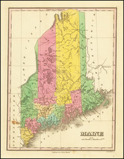
Important Early Antique Map of Maine
Ffirst state of Moses Greenleaf’s wall map of Main, published when Maine was still a district of Massachusetts.
The product of unprecedented efforts to compile the best-available information, especially regarding central and northern Maine, this map surpassed all earlier representations of the District, most notably Osgood Carleton’s map of 1801. It provided both government officials and Maine’s citizens a more accurate picture of the region’s geography and resources, and contributed much to the movement toward statehood, achieved five years later.
While earlier maps had depicted the Maine coastline with reasonable accuracy, none had depicted the central interior in much detail. Indeed, these maps left much of central and northern Maine blank or included fanciful mountains and bodies of water.
Greenleaf’s map contains a wealth of new detail. For instance, here for the first time Moosehead Lake is shown in its entirety and with a certain degree of accuracy, along with the most detailed depiction yet of the Moose River drainage and various lakes and ponds to the west of Moosehead. To the north, a number of previously uncharted lakes and river systems appear, including Chesuncook Lake and lakes identified as “Ahpmoojeene-Gamook,” “Wahlahgis-Squegamook,” and “Bungah-Quohem,” which appear to correspond to today’s Chamberlain, Eagle and Umsaskis Lakes, as well as other lakes and ponds in the region. Also notable is more extensive mapping of the headwaters and tributaries of the Penobscot and St. John Rivers. Due east of Chesuncook Lake, Mount Katahdin—the state’s highest mountain—appears for the first time on a map of Maine and very likely for the first time on any printed map.
Organizational changes in the District since the publication of Carleton’s 1801 map are reflected in the addition of three counties: Oxford, Somerset, and Penobscot (While the latter wasn’t incorporated until 1816, Greenleaf apparently considered its formation a done deal at the time of publication). One curious and intriguing feature of the map is the representation of the northeastern boundary. Whereas all previous maps show this boundary running essentially due north all the way to the mountains dividing the St. Lawrence and Maine drainages, that on Greenleaf’s map runs due north then angles to the northwest before reaching the mountains. The basis for this alteration remains a mystery. In the two later states of this map (1820 and 1822) the border terminates where the angle formerly began and a note has been added, reading “Waters falling into the Gulf of St. Lawrence.” In Greenleaf’s later maps the border simply runs due north to the mountains.
While numerous inaccuracies and uncertainties remained, Greenleaf’s first map set the stage for the increasingly accurate series of maps that he and his son would publish over the next three decades. As Greenleaf himself noted:
in general it is correct as can be expected, until a new survey of the whole, corrected by celestial observations, under the immediate inspection of persons properly qualified for the purpose, shall furnish better materials than are now existing. And, until this is done, a perfect map of Maine cannot be obtained.
In his later maps, Greenleaf would go a long way toward achieving that goal.
Rarity
The map is rare on the market. This is the first example offered publically in more than 10 years.
MacDougall, Walter M. Settling the Maine Wilderness (Portland, 2006), pp. 20-21 and p. 89
Thompson, Edward. Important Maine Maps, Books, Prints and Ephemera (Orono, 2003), #113
Thompson, Edward. Printed Maps of the District and State of Maine, 1793-1860 (Bangor, 2010), #27, pp 79-97
Ristow, Walter W. American Maps and Mapmakers (Detroit, 1986), pp. 94-96
![[New England] Tierra Nueva](https://storage.googleapis.com/raremaps/img/small/64626.jpg)
![[ Maine ] Carte Geographique, Statistique et Historique Du Maine](https://storage.googleapis.com/raremaps/img/small/79342.jpg)