|
||

|

|
|

|
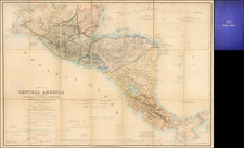
Outstanding map of Upper or New California, New Mexico, Baja California and Mexico, with a large inset of Central America and the Yucatan. Shows the apocryphal Rivers of the West extending from SF Bay to the two Salt Lakes, one of which would soon disappear w/ the Rivers. An American Fur Post at Salt Lake is noted. The cartography of the Colorado and Gila Rivers are still highly inaccurate, the former extending to the Rocky Mountains, with no sign of the Wasatch or other intervening ranges. The treatment of the Rockies from Cheyenne southward is naïve, pre-dating Fremont and other important explorations which followed in the late 1840s. The Upper California Missions are noted, as are others in Arizona, New Mexico and Utah. Many Indian Tribes noted. Bent's Fort is shown. A marvelous example of the Cartography of the SW immediately prior to the outbreak of the Mexican War.
![[ Highway Symbols! ] Automobile Road Map of California-Nevada Los Angeles and Vicinity Long Beach](https://storage.googleapis.com/raremaps/img/small/99652.jpg)

![[ Coronado Beach Broadsheet ] Map of Coronado Beach San Diego, California / Coronado Beach and Surrounding Country](https://storage.googleapis.com/raremaps/img/small/99912.jpg)