|
||

|

|
|

|
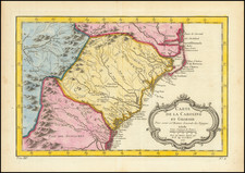
Fascinating Urban Planning Map, Illustrating the Earliest Permanent Public Housing Project in the United States, Techwood Homes, Atlanta.
Separately issued map of Atlanta, published by the Atlanta Housing Authority in 1938. The map was intended to promote the early work of the Housing Authority, which was established to ameliorate Atlanta's poor housing stock.
The key at the bottom illustrates the following:
- T. Techwood Homes (completed)
- U. University Homes (completed)
- Slum Areas
- 1. Clark Howell Homes
- 2. John Hope Homes
- 3. State Capitol Homes
- 4. Crady Homes
Techwood Homes
Wikipedia gives the following information on the Techwood Homes and University Homes projects:
Techwood Flats was a mixed-race community located between Georgia Tech and downtown Atlanta, with buildings that often lacked running water or electricity. Charles Palmer claimed that he selected Techwood Flats specifically because it lay on his commute from northwest Atlanta into downtown. At this point in time, slum clearance was seen as necessarily tied with public housing, despite the fact that public housing was not intended for habitation by the poor. Rather, public housing was meant to be a temporary aid to middle- or working-class families hurt by the depression. Thus, when the Techwood Homes public housing project was completed in 1936, few residents of the former slum were able to move back in. Furthermore, the old community had been racially mixed, whereas the new public housing project was all white. This set a precedent of public housing in Atlanta being used to shape the racial and economic composition of communities in areas of interest to the elite.
Not only was Techwood Homes the first public housing project in Atlanta, it was also the first permanent public housing project in the United States. It received recognition across the country, and in 1935 FDR gave a speech to dedicate the project. Following Techwood Homes, Atlanta's second housing project would be University Homes, intended for African-Americans and built over the demolished Beaver Slide. Even more so than with Techwood, this inhabitants of this project represented a sharp increase in income for the area. While the previous community was made of mostly unskilled laborers, University Homes was home to the black middle class, or even the upper middle class. While touted by John Hope (President of Atlanta University) and other black elites as a victory for the black community, it was emblematic of the desire of those same elites to separate themselves from the black poor. It also represented part of the serious disconnect between the goals of the black elites and middle class and the interests of the black poor.
Conclusion
Altogether this map provides an important visualization of an approach to urban planning that defined the 20th century in the United States. Namely, that blighted urban cores could be revitalized through large-scale public housing projects. Indeed, in the present map the scale of the problem is vast -- the majority of downtown Atlanta is characterized as "Slum Areas", only a small portion of which has been "rebuilt" with public housing.