


|
||

|

|
|

|
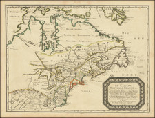
Placentia Bay, Newfoundland
An excellent map of the Bay of Placentia and environs, published by Nicolas Bellin in his Petit Atlas Maritime shortly after the conclusion of the Seven Years War.
The of the Bay of Placentia was a center of operations for Basque fishermen as early as the beginning of the 16th century. The last will of a Basque seaman has been discovered in an archive in Spain in which Domingo de Luca asks in 1563, “that my body be buried in this port of Plazençia in the place where those who die here are usually buried.” It is believed to be the oldest original civil document written in Canada.
"Placentia" may be derived from a similar name of an old Basque villa called Placencia de las Armas (Basque: Soraluze), which is located in the Gipuzkoa province of the Basque Country.
In 1655, the French made Placentia the capital, building Fort Plaisance in 1662, which was followed by Fort Royal in 1687, and Fort Saint Louis in 1691. The French garrisons at Plaisance were small, but despite that fact, the soldiers and French privateers managed to hold their own in the face of numerous English attacks during the two major conflicts of the Nine Years' War and the War of the Spanish Succession. Recollect (Franciscan) friars from New France built a friary here in 1689, which lasted until the expulsion of the French in 1714. In 1692, Louis-Armand de Lom d'Arce de Lahontan, Baron de Lahontan defended the French port.
In 1711, the British almost annihilated the French at Placentia when a Royal Navy fleet under Admiral Hovenden Walker.
In 1713, the Treaty of Utrecht forced the French to abandon their Placentia Bay settlements and migrate to Louisbourg, and Placentia became a British possession. In the spring of 1714, the governor of Plaisance began organizing the emigration. Three royal ships accompanied by merchant vessels took the French residents of Placentia to the future site of Louisbourg.
Jacques-Nicolas Bellin (1703-1772) was among the most important mapmakers of the eighteenth century. In 1721, at only the age of 18, he was appointed Hydrographer to the French Navy. In August 1741, he became the first Ingénieur de la Marine of the Dépôt des cartes et plans de la Marine (the French Hydrographic Office) and was named Official Hydrographer of the French King.
During his term as Official Hydrographer, the Dépôt was the one of the most active centers for the production of sea charts and maps in Europe. Their output included a folio-format sea atlas of France, the Neptune Francois. He also produced a number of sea atlases of the world, including the Atlas Maritime and the Hydrographie Francaise. These gained fame and distinction all over Europe and were republished throughout the eighteenth and even in the nineteenth century.
Bellin also produced smaller format maps such as the 1764 Petit Atlas Maritime, containing 580 finely-detailed charts. He also contributed a number of maps for the 15-volume Histoire Generale des Voyages of Antoine François Prévost.
Bellin set a very high standard of workmanship and accuracy, cementing France's leading role in European cartography and geography during this period. Many of his maps were copied by other mapmakers across the continent.

![[ Queen Anne's War - Failed Attack on French Canada -- Petition to Queen Anne from the Colony of New York seeking reimbursement for a failed conquest of New France during Queen Anne's War ] To the Queens most Excellent Majesty . . . 1709](https://storage.googleapis.com/raremaps/img/small/85409.jpg)
![[The Final State] A New Map of North America, with the West India Islands, Divided according to the Preliminary Articles of Peace, Signed at Versailles, 20 Jan. 1783, wherein are Distinguished The United States and the Several Provinces, Governments &c Which Compose the British Dominions . . . 1794](https://storage.googleapis.com/raremaps/img/small/89085.jpg)
![[ English Plantations in North America ] A New Map of the most Considerable Plantations of the English In America Dedicated to His Highness William Duke of Glocester.](https://storage.googleapis.com/raremaps/img/small/98233.jpg)