|
||

|

|
|

|
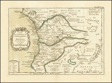
A Rare French Survey Map of the Interior of a portion of Senegal
Finely executed map of Senegal, prepared between 1873 and 1884 by Henri-Nicolas Frey.
The map is quite exceptional in its stylistic depiction of the region, employing its own relatively unique graphic style of the wetlands regions within the map.
The map was prepared during the period when the French were expanding their control of Senegal beyond the original trading posts along the coastline, into the interior regions. The map is a foundational work on the survey of Senegal, including:
- Points of Triangulation
- Wells
- Relief and contour lines.
- Areas of Cultivation of Corn, Peanuts and Cassava Melons)
- Population details (marked with an L).
- Primary and Secondary Roads
Henri-Nicolas Frey rose in 1874 to the level of Captain in Senegal and later squadron leader in 1880 Frey served with the French Marine Infantry Troops and was reporter of the Technical Committee of the Colonies. He was rose to the level lieutenant-colonel in 1884, then proceeded to Tonkin, before returning to Africa in 1887.
The map was published during the period that Senegal was represented in the French Parliament by Alfred Gasconi, the only parliamentary representation from sub-Saharan Africa anywhere in a European legislature.
French Colonial Senegal
A number of nations competed for control of the Senegal region from the 15th Century until 1677, when France wound up with control of the region as part of its slave trade. In 1758 the French settlement was captured by a British expedition as part of the Seven Years' War, but was recaptured by the Duke of Lauzun and Lauzun's Legion of Foreigners in 1779, at the outset of the French War with England and the American Revolution.
In the 1850s, under Governor Louis Faidherbe, France began to expand into the Senegalese mainland, at the expense of the native kingdoms.
The Four Communes or Quarter of Saint-Louis, Dakar, Gorée, and Rufisque were the oldest colonial towns in French controlled west Africa.
On April 27, 1848, following the February revolution in France, a law was passed in Paris enabling the Four Quarter to elect a Deputy to the French Parliament for the first time. On April 2, 1852, the parliamentary seat for Senegal was abolished by Napoleon III. Following the downfall of the French Second Empire, the Four Quarters was again allowed a parliamentary seat which was granted by law on February 1, 1871. On December 30,1875 this seat was again abolished, but only for a few years as it was reinstated on April 8,1879, and remained the single parliamentary representation from sub-Saharan Africa anywhere in a European legislature until the fall of the third republic in 1940.
Rarity
The map is very rare. We note only the example in the Bibliotheque National de France.


![[Southwestern Coast of Africa] Pas-Caart van Guinea en de Custen daer aen gelegen Van Cabo verde tot Cabo de Bona Esperanca](https://storage.googleapis.com/raremaps/img/small/46931.jpg)