|
||

|

|
|

|
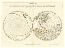
A Fascinating Marriage of Precise French Cartography and Dutch Baroque Embellishment
Fine old color example of this rare double hemisphere map of the world on a polar projection.
First state of Pierre Mortier's rare world map, which combines the 1657 double polar projection by Nicolas Sanson and the famous, highly decorative border scenes from the Visscher/Berchem map of 1658.
Mortier credits Sanson in his title. Australia is depicted as part of a massive southern continent. Greenland is connected to the Arctic regions. Both of these misconceptions have been corrected in the two smaller spheres, drawn so that Paris lies at the center, which appeared on Mortier’s Mappe Monde of 1696.
The great mapmakers of the 17th and 18th centuries were notorious for borrowing and stealing the best of each others work, buying up the original plates when they could, or re-engraving their own versions of popular maps. This map by Mortier brings together elements from different sources, which, combined with rich original coloring result in a particularly beautiful and unusual world map.
The map includes allegorical scenes by Nicolaes Berchem representing:
- The rape of Persephone
- Zeus being carried across the heavens in an eagle-drawn chariot
- Poseidon commanding his entourage,
- Demeter receiving the fruits of the Earth.
Rarity
This is the first state of the map, bearing only the Mortier imprint. A later state was issued by Covens & Mortier.
The first state of the map is quite rare on the market. The last example appeared in a Richard Arkway Catalog in July 2007 (priced at $7,500).
Provenance: Goodyear Sale, Rachel Davis Auctioneer, Cleveland Ohio.
Pierre, or Pieter, Mortier (1661-1711) was a Dutch engraver, son of a French refugee. He was born in Leiden. In 1690 he was granted a privilege to publish French maps in Dutch lands. In 1693 he released the first and accompanying volume of the Neptune Francois. The third followed in 1700. His son, Cornelis (1699-1783), would partner with Johannes Covens I, creating one of the most important map publishing companies of the eighteenth century.
![[Early Fascimile of the Disputed Christopher Columbus Portolan Chart]](https://storage.googleapis.com/raremaps/img/small/66588.jpg)