|
||

|

|
|

|
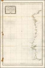
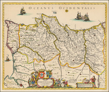
Southern Portugal At The Beginning of the Reign of King Jose I
Nice example of the first edition of De Vaugondy's map of the southern part of Portugal.
Lisbon and the Barra da Lisboa are prominently featured. Several hundred towns are shown.
During the middle of the 18th century, Portugal was in a period of significant change and development, particularly during the reign of King Joseph I from 1750 to 1777. This era, often known as the "Age of Enlightenment" in Portugal, was characterized by far-reaching reforms and the strengthening of royal power.
King Joseph I's rule is often synonymous with the de facto rule of Sebastião José de Carvalho e Melo, better known as the Marquis of Pombal, who served as his prime minister. Pombal is a controversial figure in Portuguese history. While some see him as a despot who ruled with an iron fist, others view him as a progressive reformer who modernized Portugal's economy and education system.
Pombal implemented a number of reforms aimed at strengthening the power of the monarchy and reducing the influence of the nobility and the church. He expelled the Jesuits from Portugal and its colonies, confiscated their property, and placed education under the control of the state. These measures were in line with the Enlightenment ideals of rationality and secularism, and they made Pombal a lot of enemies, especially among the traditional elites.
In economic terms, Pombal pursued policies aimed at making Portugal less dependent on colonial wealth and promoting domestic industries. He implemented measures to reorganize the wine industry, which led to the creation of the famous Port wine, and to regulate trade between the metropolis and the colonies.
The map was issued in the same decade as the Great Lisbon Earthquake of 1755, which nearly destroyed the capital. Pombal took charge of the reconstruction, rebuilding the city center in the Pombaline style, characterized by a grid street plan and earthquake-resistant construction methods.
However, Pombal's authoritarian rule also led to political repression and the Távora affair, a politically motivated trial and execution of several members of the nobility, which tarnished his legacy.
Gilles Robert de Vaugondy (1688-1766) and Didier Robert de Vaugondy (1723-1786) were influential figures in the realm of 18th-century French cartography. Originating from Paris, their contributions to mapmaking were significant during an era of expansive geographical exploration.
Gilles Robert de Vaugondy entered the world of cartography not through family tradition but through personal interest and the budding opportunities of his time. Born in 1688, he worked during a time when Paris was becoming a central hub for cartographic activities. Gilles often incorporated the latest findings from explorers into his maps, making them sought-after for their contemporary relevance. His connections weren't limited to his immediate circle; he frequently interacted with other key mapmakers, staying updated on the latest techniques and findings.
His son, Didier, was born in 1723 and had the advantage of growing up surrounded by maps and globes. While his father was renowned for maps, Didier made a name for himself in the field of globemaking. His globes were some of the most precise and detailed in France, gaining recognition even among the royalty. In addition to his work in cartography and globemaking, Didier had a keen interest in education, especially after the expulsion of the Jesuits from France. He stepped in to produce geographical educational materials, fulfilling a newfound need.
The maps and globes produced by the Vaugondys remain an enduring testament to the peak of French cartography during the Enlightenment. Their works, characterized by precision and the inclusion of contemporary findings, helped to shape our understanding of the world during a transformative period in European history.
![Atlantic Islands [Azores, Madeira, Canary and Cape Verde]](https://storage.googleapis.com/raremaps/img/small/94761.jpg)