|
||

|

|
|

|
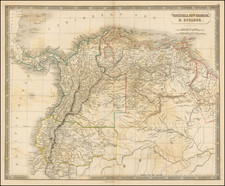
An Important and Highly Influential Map of Ecuador
Rare and highly detailed map of Ecuador, published in Quito and printed in Paris.
Galindo's map of Ecuador was the third "Official" map of Ecuador, following the work of Teodoro Wolf in 1892. The map was printed on 4 sheets and published by Henry Barrere, 21 Rue du Bac, Paris.
14 years after the publication of the map of Teodoro Wolf and within the context of one of the several military crises due to border problems with Peru, the Ecuadorian government, for the third time, opted to replace the official map of the country . While recognized as a map of scientific rigor, Wolf's map did not resolve some of the more sensitive boundary issues in Ecuador's favor. Wolf's emphasis was on the topographic and hydrographic construction of the territory, but was thought to be deficient in its delineation of Ecuador's borders. In fact, the eastern territory that was disputed between Peru and Ecuador was thought to be inadequate, with important sections treated only within an inset.
The map which replaced Wolf's map was produced by the Dominican Friar Enrique Vacas Galindo (1865-1938). In this new cartographic representation, it includes not only the territory that was marginalized by Wolf, but a large section that at that time was under Peruvian control.
Unlike his predecessors, Vacas Galindo delivers historical and political depth to the territory and stops seeing it as a network of mountains, rivers, streams and valleys, delineating Ecuador's historical claims. Within this context, his contribution to the problem of the national territory focuses on his archival research and on the large number of historical documents that he contributes to the discussion. Vacas Galindo questions the premise put forth by Peru that Ecuador did not have sufficient documentation to justify its rights over the territories disputed by Peru in the Eastern region. This erroneous belief, in the opinion of Vacas Galindo, was due to the insufficient attention paid by the Governments of Ecuador to the study of the question of borders, a premise born out by Wolf's map.
At the time of the map's publication, the Journal of the American Geographical Society of New York, Volume 39 (1907), at page 755, noted as follows:
A notable map, to which Father Galindo, long a resident of Ecuador, devoted years of labour. His own extended travels enabled him to place on the map a considerable number of rivers hitherto unknown; and in the compilation he used all serviceable map material, including Dr. Wolf's map, which was especially helpful in the Andean region.
The historical feature relates to the boundaries as fixed by treaty or claimed by adjacent countries, and all of them are depicted in colours. The mountains are shown in brown and the hydrography in blue, the distribution of the numerous Indian tribes and the head of navigation on the rivers are marked, and the relative importance of places is indicated by the different sizes of type.
The mechanical production of the map in Paris was excellent. Railroads are shown as in operation, building, or projected. The Government, which defrayed the expense of producing the work, has given it official standing, and requires that it be used in the universities and colleges of the republic.
This product of great labour is fully worthy of such an endorsement.
Rarity
This is the first example we have ever seen on the market.
![[ Peru ] Mapa Mineralogico del Peru](https://storage.googleapis.com/raremaps/img/small/100116.jpg)
![[Peruvian and Bolivian Coast] Sheet XI Bolivia and Peru Cape Paquica To Cape Lobos By Captn. Robert Fitz Roy R.N. The Officers of H.M.S. Beagle 1836](https://storage.googleapis.com/raremaps/img/small/73464rd.jpg)