This item has been sold, but you can enter your email address to be notified if another example becomes available.


|
||

|

|
|

|
Stock# 58004mp2
Description
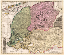
A fine early map of the Utrecht region, which appeared in Petrus Kaerius's (Peter Van der Keere) Germaniae Inferior id est, XVII Provinciarum ejus novae et exactae Tabulae Geographicae, first published in Amsterdam in 1617.
Van der Keere's atlas was the first separately published atlas of the Low Countries.
The map includes a view of Utrecht, multiple coats of arms, and costumes showing typical regional dress.
Condition Description
Minor split at centerfold.
![[Nymmegen] Novimagium sive Noviromagum vulgo Nijmmegen . . . .](https://storage.googleapis.com/raremaps/img/small/44358.jpg)
![[Napoleon's Battles in France, Belgium Netherlands, Luxembourg, Germany] No. 1 Frontiere du Nord. Mesny 5.](https://storage.googleapis.com/raremaps/img/small/60727.jpg)