


|
||

|

|
|

|
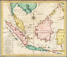
Rare English Sea Chart of the Indian Ocean and Southeast Asia
Fine example of this rare English Sea Chart of Southeast Asia, the Philippines and contiguous regions.
Prepared in the style of a Portolan Sea Chart, Herberts chart covers the coasts of India, Malaysia, Philippines and the Indonesian archipelago. The top of Australia is shown as the Southern Land.
The lack of knowledge in the region is evidenced by the many incomplete southern and western coastlines in New Guinea and the islands to the south.
Henry Gregory (1744-1782) was a British mathematical and optical instrument maker. One of his azimuth compasses accompanied James Cook on his second voyage to the Pacific (1772-1775). The chart appeared as one of 46 in "A New Directory for the East Indies". This directory was designed for professional rather than popular use and valued in commercial as well as military navigation, hence a very low survival rate.
![[Macao, Hong Kong & Environs] Carte de L'Entree de la Riviere De Canton dans la Chine](https://storage.googleapis.com/raremaps/img/small/74473.jpg)
![(Southeast Asia) [Unpublished Manuscript Sailing Directions from Europe to China by a French Navigational Officer]](https://storage.googleapis.com/raremaps/img/small/90507.jpg)