|
||

|

|
|

|
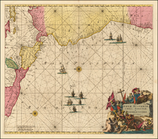
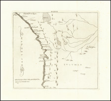
Remarkable sea chart of the Coast of Patagonia, published by the French Hydrographic Survey.
The cartographic details shown on the chart are based in large part on two hydrographic surveys of the coast, the first being the expedition (1826–1830) including HMS Adventure and HMS Beagle under Phillip Parker King, and the second (1832–1836) being the voyage of the Beagle under Robert FitzRoy. The latter expedition is particularly noted for the participation of Charles Darwin who spent considerable time investigating various areas of Patagonia onshore, including long rides with gauchos in Río Negro, and who joined FitzRoy in a 200 miles expedition taking ships boats up the course of the Santa Cruz river.
The present chart is based upon information compiled in 1847 and revised to 1866.
The chart includes manuscript annotations of a voyage along the coast in 1867 and 1868.
The Dépôt de la Marine, known more formally as the Dépôt des cartes et plans de la Marine, was the central charting institution of France. The centralization of hydrography in France began in earnest when Jean-Baptiste Colbert became First Minister of France in 1661. Under his watch, the first Royal School of Hydrography began operating, as did the first survey of France’s coasts (1670-1689). In 1680, Colbert consolidated various collections of charts and memoirs into a single assemblage, forming the core of sources for what would become the Dépôt.
The Dépôt itself began as the central deposit of charts for the French Navy. In 1720, the Navy consolidated its collection with those government materials covering the colonies, creating a single large repository of navigation. By 1737, the Dépôt was creating its own original charts and, from 1750, they participated in scientific expeditions to determine the accurate calculation of longitude.
In 1773, the Dépôt received a monopoly over the composition, production, and distribution of navigational materials, solidifying their place as the main producer of geographic knowledge in France. Dépôt-approved charts were distributed to official warehouses in port cities and sold by authorized merchants. The charts were of the highest quality, as many of France’s premier mapmakers worked at the Dépôt in the eighteenth century, including Philippe Bauche, Jacques-Nicolas Bellin, Rigobert Bonne, Jean Nicolas Buache, and Charles-François Beautemps-Beaupré.
The Dépôt continued to operate until 1886, when it became the Naval Hydrographic Service. In 1971, it changed names again, this time to the Naval and Oceanographic Service (SHOM). Although its name has changed, its purpose is largely the same, to provide high quality cartographic and scientific information to the France’s Navy and merchant marine.
![[Tierra Del Fuego / Straits of Magellan, etc.] Carte Des Cotes de L'Amerique Meridionale depuis le Parallele 36° 30' late. Sud jusqu'au Cap de Horn Levée en 1789, 1790, &c. par des officiers de la Marine en 1800](https://storage.googleapis.com/raremaps/img/small/57719.jpg)