|
||

|

|
|

|
Stock# 57795
Description
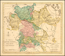
An interesting regional map, showing the Dutchys of Bremen, Holstein, Mecklenberg, Schwerin, Gustro, Magdeburg, Verden, Saxe Launberg, the County of Dannenberg, a group of southern Principalities including Calenburg, Grubenhagen, Haaberstadt, Wolfenbuttel, Hildesheim, and Luneburg-Zell, and a host of Bishopricks, Archbishopricks etc.
Shows towns, rivers, mountains, lakes, etc.
Robert Wilkinson was active in London as a cartographic publisher from 1785 to 1825. He produced a number of nice works, including a General Atlas and a re-issuance of Bowen & Kitchen's English Atlas, along with excellent large format separate maps.
![Turingiae Noviss Descript. Per Iohannem Mellinger Halens [with] Misniae et Lustaiae Tabula Descripta a. M Bartholomeao Sculteto Gorlit.](https://storage.googleapis.com/raremaps/img/small/61448.jpg)
![[Wroclaw Plan] A New & Accurate Map of the North East part of Germany, containing the Dominions of the Electors of Saxony & Brandenburg [and] A Plan of the City of Breslaw Capital of Silefia](https://storage.googleapis.com/raremaps/img/small/80094.jpg)