|
||

|

|
|

|
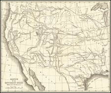
Fine example of Finley's large format map of North America.
Finley's map of North America is one of the first maps of North America printed in the United States following the signing of the Adams Onis Treaty. The map provides an excellent overview of the now-relatively settled boundaries in the West following the Louisiana Purchase and agreements with England regarding the US-British America Border, extending west to the Rocky Mountains. Of course, it would be another 20 years before the Oregon Question would be resolved.
Russian Possessions (Alaska) and a large 54 40 or fight border with the Russian Possessions dominate the map, a serious political statement for the period.
The region of the Northwest bounded by Upper California and Russian Possessions is still Missouri Territory, and contains the best information from Lewis & Clark and the Hunt & Stuart expedition for Astoria, although the Oregon Trail is not yet shown. The US / Russia Border is settled by the Convention of April 1824.
Excellent detail in the Rocky Mountains and Texas, which is shown as Intendency of San Luis Potosi, Galveston, Loredo, San Antonio, Mier, Revilla and Vicente, and appear on the Rio Grande. Notes of the Wako Indians, Comanches Indians and Curancaways are also present in Texas.
Many Indian Tribes throughout the West. A number of long mythical rivers in Upper California flow from the Great Basin to the Pacific. Double wide Arkansas Territory and large Northwest Territory.
Anthony Finley (1784-1836) was an American map publisher. Little is known about his life. He is presumed to have been born in Philadelphia, where he also died. A publisher, Finley was also involved in several Philadelphia civic and professional societies such as the Philadelphia Apprentices’ Library. He may have been in business as early as 1809 and his first publication dates from ca. 1811.
His first maps also date from this year, with two maps in Daniel Edward Clarke’s Travels in Various Countries of Europe, Asia, and Africa. The first atlas published by Finley appeared in 1818, the Atlas classica, or, Select maps of ancient geography, both sacred and profane, for the use of colleges and schools in the United States. He is best known for his A New General Atlas Comprising a Complete Set of Maps (1824), which was a bestseller. There were two editions in 1824, with annual editions until 1834.
Finley was part of the first generation of American publishers who produced high quality, precise maps on American soil. He was in competition with other Philadelphia publishers, for example Henry S. Tanner. Finley’s A New American Atlas Designed Principally to Illustrate the Geography of the United States of America (1826) closely mirrors Tanner’s A New American Atlas Containing Maps of the Several States of the North American Union, with similar groupings of maps; the main difference is the smaller scale of Finley’s maps. Finley printed two editions of this atlas.
![[United States Independence After The Revolution] A New Map of North America, with the West India Islands, Divided according to the Preliminary Articles of Peace, Signed at Versailles, 20 Jan. 1783, wherein are particularly Distinguished The United States, and the Several Provinces, Governments &ca, which Compose the British Dominions . . . 1783](https://storage.googleapis.com/raremaps/img/small/70734.jpg)
![Carte Des Etats-Unis Du Mexique 1836 [Republic of Texas]](https://storage.googleapis.com/raremaps/img/small/103417.jpg)