


|
||

|

|
|

|
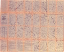
A meticulously detailed map of India from the 19th century providing a fascinating snapshot of the region during a time of significant change.
Published by Edward Stanford in London in 1869, this map captures the political and administrative divisions, cities, towns, roads, railroads, mountains, and rivers of the Indian subcontinent and its surrounding regions. The map's extent ranges from Turkestan and southern China in the north to the Maldives, Ceylon, and Sumatra in the south, while also encompassing all of Burma and extending westward to Beluchistan. Relief is shown by hachures, and the prime meridian is marked at Greenwich.
Notably, the map sheds light on some of the geopolitical tensions of the time, such as the contentious status of the region referred to as 'Bod or Tibet,' which neighbors the disputed territory of 'Cashmere.' The inclusion of such details offers valuable insights into the political landscape of the period, allowing historians and collectors alike to delve deeper into the complexities of 19th-century Asia.
In summary, the map is an invaluable resource for those interested in the historical geography of the Indian subcontinent and its surrounding regions. The remarkable level of detail and its portrayal of the geopolitical intricacies of the time make it an important artifact of 19th-century cartography.
Edward Stanford (1827-1904) was a prominent British mapmaker and publisher. A native of Holborn in the heart of London, Edward was apprenticed to a printer and stationer at the age of 14. After his first master died, he worked with several others, including Trelawny W. Saunders of Charing Cross. Saunders oversaw young Edward’s early career, ensuring that he became a Fellow of the Royal Geographical Society. Associations with the Society eventually brought Sanders much business and gave him a reputation as a publisher of explorers. As testament to this reputation, the Stanford Range in British Columbia was named for him by John Palliser.
Stanford briefly partnered with Saunders in 1852 before striking out on his own in 1853. He was an agent for the Ordnance Survey, the Admiralty, the Geological Survey, the Trigonometrical Survey of India, and the India Office. He also controlled the maps of the Society for the Diffusion of Useful Knowledge, another lucrative source of income. In 1857, Stanford founded his namesake Geographical Establishment, with Saunders and A. K. Johnston as engravers. Thereafter, Stanford was known for his “library maps”, particularly those of Africa and Asia.
Addresses and Years of Operation:
- 6 Charing Cross, London (1848): Edward Stanford's initial place of employment at Trelawney Saunders' shop.
- 7 and 8 Charing Cross, London (1853): Stanford expanded his shop to these addresses.
- 55 Charing Cross, London (1873): The shop moved to this larger location.
- 12-14 Long Acre, London (1873): Site of the new print works and current flagship store.
- 7 Mercer Walk, London (2019): Stanfords moved to this address, continuing its legacy.
Stanford's work with Chief Cartographer John Bolton, including the 1858 Library Map of Europe, positioned the company as a leader in quality cartography during a time of exploration and colonialism. Their 1862 Library Map of London earned acclaim from the Royal Geographical Society. With the business thriving, Stanford purchased Staunton & Son in 1877 and, upon retiring in 1885, handed over the reins to his son, Edward Stanford II.
As sole agents for Ordnance Survey Maps, the company's influence and reputation grew, culminating in the Stanford’s London Atlas Of Universal Geography, which was presented to Queen Victoria in 1887. The transition into the 20th century saw further integration of retail, print, and cartographic operations at Long Acre.
During World War I, Stanford's became an essential publisher for the War Office. Edward Fraser Stanford took over in 1917, steering the company through the interwar period and innovations, such as the world’s smallest maps in 1922 and the Daily Mail Motor Road Map in 1926.
Withstanding a bombing in WWII, the company continued under the stewardship of John Keith Stanford and was sold to George Philip & Son in 1947. As it adapted to the digital age, Stanfords received the Ordnance Survey Premier Partner status in 2007 and ventured into online mapping and data services.
Stanfords, now an icon for travellers and explorers, has maintained its cultural relevance and retail success well into the 21st century, underpinned by a legacy of entrepreneurial spirit and commitment to cartographic excellence.
![Calcutta & Howrah Guide Map [with] Calcutta & Howrah Guide Map (1st Edition 1933) Alphabetical Index to Names. Tape Indicator Issue.](https://storage.googleapis.com/raremaps/img/small/101270.jpg)
![[ India -- With Epitaph Lieutenant Edward Holmes ] To Mark Wood Esq. M.P. Colonel of the Army in India Late Chief Engineer and Surveyor General, Bengal. This Map of India Compiled from various Interesting and Valuable Materials Is Inscribed in grateful Testimonial of his Liberal Communications By his obedient and most humble Servant A. Arrowsmith . . . 1804](https://storage.googleapis.com/raremaps/img/small/99889.jpg)
![[Ambon Island] Caart van het Eyland Amboina in 't bijsonder](https://storage.googleapis.com/raremaps/img/small/76744.jpg)