|
||

|

|
|

|
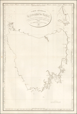
Fine example of Arrowsmith's map of Tasmania, and one of the earliest separate maps of the island. Abel Tasman (1609? - 1659), a Dutch navigator, discovered the island in 1642 and named it Van Diemen's Land.
At the time, Van Diemen's Land was still a primary destination for British convicts. The map is highly detailed with all convict stations, towns, and roads
In 1803, a British expedition was sent from Sydney to Tasmania to establish a new penal colony there. Led by Lt. John Bowen, a settlement was created at Risdon Cove, on the Derwent River. Originally sent to Port Philip, another expedition led by Lieutenant-Colonel David Collins arrived soon after. Dissatisfied with the first settlement, in 1804 an alternative settlement on the western side of the river at Sullivan's Cove was set up at what would later become known as Hobart.
When the convict station on Norfolk Island was abandoned in 1807-1808, the remaining convicts and free settlers were transported to Hobart. Starting in 1816, more free settlers began arriving from Great Britain. On December 3, 1825, Tasmania was declared a colony separate from New South Wales.
The Macquarie Harbor penal colony on the West Coast of Tasmania was established in 1820. In 1830, the Port Arthur penal settlement was established to replace Macquarie Harbor, as it was easier to maintain regular communications by sea. The continuation of transportation of convicts to Van Diemen's Land saw the rise of a well-coordinated anti-transportation movement, especially following a severe economic depression in the early 1840s. Transportation was temporarily suspended in 1846 but soon revived. By the late 1840s, most convicts being sent to Van Diemen's Land (plus those to Victoria) were designated as "exiles" and were free to work for pay while under sentence.
In 1850 the Australasian Anti-Transportation League was formed to lobby for the permanent cessation of transportation, its aims being furthered by the commencement of the Australian gold rushes the following year. The last convict ship to be sent from England, the St. Vincent, arrived in 1853.
The Arrowsmiths were a cartographic dynasty which operated from the late-eighteenth century to the mid-nineteenth. The family business was founded by Aaron Arrowsmith (1750-1823), who was renowned for carefully prepared and meticulously updated maps, globes, and charts. He created many maps that covered multiple sheets and which were massive in total size. His spare yet exacting style was recognized around the world and mapmakers from other countries, especially the young country of the United States, sought his maps and charts as exemplars for their own work.
Aaron Arrowsmith was born in County Durham in 1750. He came to London for work around 1770, where he found employment as a surveyor for the city’s mapmakers. By 1790, he had set up his own shop which specialized in general charts. Arrowsmith had five premises in his career, most of which were located on or near Soho Square, a neighborhood the led him to rub shoulders with the likes of Joseph Banks, the naturalist, and Matthew Flinders, the hydrographer.
Through his business ties and employment at the Hydrographic Office, Arrowsmith made other important relationships with Alexander Dalrymple, the Hudson’s Bay Company, and others entities. In 1810 he became Hydrographer to the Prince of Wales and, in 1820, Hydrographer to the King.
Aaron Arrowsmith died in 1823, whereby the business and title of Hydrographer to the King passed to his sons, Aaron and Samuel, and, later, his nephew, John. Aaron Jr. (1802-1854) was a founder member of the Royal Geographical Society (RGS) and left the family business in 1832; instead, he enrolled at Oxford to study to become a minister. Samuel (1805-1839) joined Aaron as a partner in the business and they traded together until Aaron left for the ministry. Samuel died at age 34 in 1839; his brother presided over his funeral. The remaining stock and copper plates were bought at auction by John Arrowsmith, their cousin.
John (1790-1873) operated his own independent business after his uncle, Aaron Arrowsmith Sr., died. After 1839, John moved into the Soho premises of his uncle and cousins. John enjoyed considerable recognition in the geography and exploration community. Like Aaron Jr., John was a founder member of the RGS and would serve as its unofficial cartographer for 43 years. Several geographical features in Australia and Canada are named after him. He carried the title Hydrographer to Queen Victoria. He died in 1873 and the majority of his stock was eventually bought by Edward Stanford, who co-founded Stanford’s map shop, which is still open in Covent Garden, London today.
![[ Australia ] Australien](https://storage.googleapis.com/raremaps/img/small/98068.jpg)
![[Tasmania] Van-Dieman's Land](https://storage.googleapis.com/raremaps/img/small/71538.jpg)