|
||

|

|
|

|
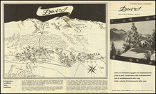
Fascinating map of Cape Cod and Martha's Vineyard, originally drawn by Ernest Dudley Chase and later revised by his wife, Clara Katrina Chase.
The present example is the second edition of the map, which pre-dates the vignette of President Kennedy's Summer Home.
The map includes Martha's Vineyard, Nantucket, Falmouth, Hyannis, Plymouth, Provincetown, and Chatham, and depicts images of major sites and attractions, including the Cape Cod Canal, highways, railroads, beaches, boats, seagulls, beachgoers, and lighthouses. Also featured are Plymouth Rock, the "Good Ship Mayflower," and Martha's Vineyard State Park. Inset illustrations of historic buildings and tourist attractions such as Brewster's Old Windmill and "A Bit of Provincetown" decorate the upper, lower and right margins.
Other decorative embellishments include a compass rose with a rope border surmounted by an anchor, and a cartouche flanked by pine needles, vines, and a codfish.
![[World] Dated Events War Map . . .](https://storage.googleapis.com/raremaps/img/small/88833.jpg)