|
||

|

|
|

|
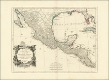
The "Territory In Dispute East" of The Mississippi River
Rare map centered on the Mississippi River, showing the "Territory in Dispute" between France and England.
The map is centered on the Mississippi River valley and the Gulf Coast, showing the colonial holdings in the southern portion of the continent then disputed and finally resolved by the Treaty of Paris in 1763.
The British colonies of North and South Carolina, Virginia and Georgia are shown with their western borders on the Mississippi River. A note across the western portion of these three Colonies states they are "Territory in Dispute."
The region west of the Mississippi is labeled Louisiana with several Indian nations located. Present-day Texas is labeled Country of the Cenis and Wandering Indians.
Rarity
The map is very rare. No prior examples in Antique Map Price Records. First example we have ever seen. We have never had a map from the British Magazine.
![Louisiana [inset:] Vicinity of New Orleans](https://storage.googleapis.com/raremaps/img/small/87567.jpg)
![[Battle of Yorktown] Plan D'York en Virginie avec les attaques et les Campemens de l'Armee combinee de France et d'Amerique](https://storage.googleapis.com/raremaps/img/small/102603.jpg)
![(18th-Century Southern Borderlands) [Collection of manuscript letters to Secretary of War James McHenry from confidential U.S. agent John McKee, relating to southern borderlands, Native Americans and Panton, Leslie & Co.; a letter from John McKee written from Mobile, Alabama, to William Blount of Blount's Conspiracy fame; a letter from William Panton concerning John McKee; and letters from Felix D. St. Hilaire, concerning General Victor Collot]](https://storage.googleapis.com/raremaps/img/small/90005.jpg)