|
||

|

|
|

|
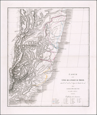
Fine large format sea chart of the Coast of Brazil, with large inset maps of the Entrances to Villa Grande and the Harbor of Rio Janeiro, pubished in London in 1808.
The chart was issued in 1808, the year the Portuguese court relocated to Rio de Janiero, fleeing Napoleon and the Peninsular Campaign, which was then in progress, having left Lisbon on November 29, 1807.
Oriented with North at the top, the chart is exceptionally detailed. The chart is based upon surveys conducted under the auspices of the Portuguese Navy around the turn of the century. During the first half of the 19th Century, both British and American mariners were making frequent visits to Brazil's ports and sailing along its coastlines. Britain was a longtime ally of Portugal and maintained extensive trade links with ports such as Rio de Janeiro and Bahia. Vessels of the Royal Navy also frequently reprovisioned in Brazil before and after rounding Cape Horn. This chart would have been very useful during its time, as it would have been the first accurate general chart of Rio de Janeiro Harbor.