|
||

|

|
|

|
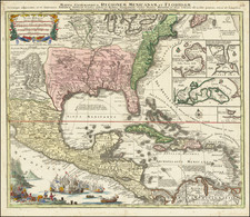
Early regional map from Duval's Le Monde Terrestre, first published in 1659, although no copy located pre-dates 1660.
Includes an early depiction of the Chesapeake region, the mythical Lake May above Floride, Jamestown, Cape Henry, Secot, Pomeiok, an early reference to Manhattan and New Amsterdam and an inset of Bermuda.
This is the fourth state of the map. The states can be identified as follows:
- 1659 / 1660: Title is La Virginie Par P. Duval Geogra. du Roy 1659
- 1661: Title is changed to La Virginie Par P. Duval Geographe du Roy A. Paris. 1659
- 1663: Date is removed
- 1672: After Nouvel Amsterdam, the words "al-Manhate" have been added, as are N. Holland after N. Pais Bas. The words Iroquois and Melilot are also added.
- 1687: Plate Number 9 added at bottom right corner
Pierre Duval (1618-1683) was a French geographer, cartographer, and publisher who worked in Abbeville and Paris during the seventeenth century. He was born in the former city, in northeast France, before moving to Paris. Duval was the nephew of the famous cartographer Nicolas Sanson, from whom he learned the mapmaker's art and skills. Both men worked at the royal court, having followed the royal request for artists to relocate to Paris. In addition to numerous maps and atlases, Du Val's opus also includes geography texts. He held the title of geographe ordinaire du roi from 1650 and died in 1683, when his wife and daughters took over his business.

![[Amherst County Survey of 200 Acres Owned by Captain James Dillard dated 16, 1822]](https://storage.googleapis.com/raremaps/img/small/73745.jpg)