


|
||

|

|
|

|
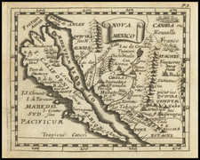
One of The Few Maps to Focus on the Island of California
Rare miniature map of California and the contiguous parts of Mexico and the Southwest, published by Pierre Du Val in Paris.The projection is based on Sanson.
The map covers all of what would now be New Mexico, Arizona, Utah, Nevada and parts of Oregon and Idaho, extening to the area described as "Canada ou Nouvelle France".
The map shows Cibola, Anian, Quivira and many other mythical places. A fine example of California as an island, one of only a handful of maps to focus on the island as it main feature.
A difficult to acquire, rare map of California and the Southwest.
Pierre Duval (1618-1683) was a French geographer, cartographer, and publisher who worked in Abbeville and Paris during the seventeenth century. He was born in the former city, in northeast France, before moving to Paris. Duval was the nephew of the famous cartographer Nicolas Sanson, from whom he learned the mapmaker's art and skills. Both men worked at the royal court, having followed the royal request for artists to relocate to Paris. In addition to numerous maps and atlases, Du Val's opus also includes geography texts. He held the title of geographe ordinaire du roi from 1650 and died in 1683, when his wife and daughters took over his business.
![[Northern California] North Bay Horse Country](https://storage.googleapis.com/raremaps/img/small/86802.jpg)
![Mexico [Texas on the Eve of Independence]](https://storage.googleapis.com/raremaps/img/small/84917.jpg)